IMAGES TAKEN NEAR TO
Angelica Mews, TEWKESBURY, GL20 7FJ
Introduction
This page details the photographs taken nearby to Angelica Mews, GL20 7FJ by members of the Geograph project.
The Geograph project started in 2005 with the aim of publishing, organising and preserving representative images for every square kilometre of Great Britain, Ireland and the Isle of Man.

There are currently over 7.5m images from over14,400 individuals and you can help contribute to the project by visiting https://www.geograph.org.uk
Image Map
Images are licensed for reuse under creativecommons.org/licenses/by-sa/2.0
Notes
- Clicking on the map will re-center to the selected point.
- The higher the marker number, the further away the image location is from the centre of the postcode.
Image Listing (11 Images Found)
Images are licensed for reuse under creativecommons.org/licenses/by-sa/2.0
Image
Details
Distance
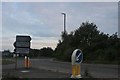
1
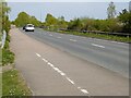
A38 bridge over River Swilgate, near Tewkesbury
Image: © David Smith
Taken: 16 Jun 2018
0.19 miles
4
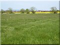
Farmland beside the River Swilgate
Farmland beside the River Swilgate with a modern housing development in the background.
Image: © Philip Halling
Taken: 24 Apr 2021
0.20 miles
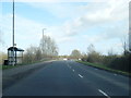
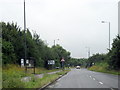
5
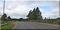
The A38 bypassing Tewkesbury
This bypass at Tewkesbury links the A38 from the south with the A438 to the east of the town.
Image: © Philip Halling
Taken: 24 Apr 2021
0.20 miles
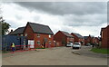
6
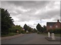
Monterey Road, the Wheatpieces, Tewkesbury
Image: © David Smith
Taken: 16 Jun 2018
0.20 miles
8
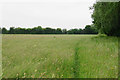
Footpath through long grass
The path is just about discernible.
Image: © Bill Boaden
Taken: 4 Jun 2018
0.23 miles
10
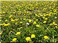
Dandelion flowers
A field of dandelions.
Image: © Philip Halling
Taken: 24 Apr 2021
0.23 miles