IMAGES TAKEN NEAR TO
Brasenose Road, TEWKESBURY, GL20 7EJ
Introduction
This page details the photographs taken nearby to Brasenose Road, GL20 7EJ by members of the Geograph project.
The Geograph project started in 2005 with the aim of publishing, organising and preserving representative images for every square kilometre of Great Britain, Ireland and the Isle of Man.

There are currently over 7.5m images from over14,400 individuals and you can help contribute to the project by visiting https://www.geograph.org.uk
Image Map
Images are licensed for reuse under creativecommons.org/licenses/by-sa/2.0
Notes
- Clicking on the map will re-center to the selected point.
- The higher the marker number, the further away the image location is from the centre of the postcode.
Image Listing (259 Images Found)
Images are licensed for reuse under creativecommons.org/licenses/by-sa/2.0
Image
Details
Distance
1
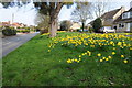
Daffodils in Bredon
Daffodils beside the B4080 in Bredon.
Image: © Philip Halling
Taken: 29 Mar 2014
0.01 miles
2
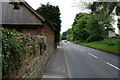
High Street, Bredon
Looking east into the village.
Image: © David Lally
Taken: 20 May 2010
0.03 miles
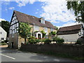
3

College Farmhouse, Bredon
A 17th century timber framed farmhouse. The farm used to be a dairy farm for Balliol College, Oxford. The plaque by the door now reads Old College Farm. Listed Grade II.
Image: © Chris Allen
Taken: 17 Jan 2022
0.06 miles
4
College Farmhouse
When a working farm supplied milk to Balliol College, Oxford http://www.britishlistedbuildings.co.uk/en-442287-college-farmhouse-bredon-worcestershire
Image: © Jonathan Thacker
Taken: 29 Jun 2014
0.07 miles
5
The Farm and College Farmhouse
The Farm (white building) dates from the eighteenth century http://www.britishlistedbuildings.co.uk/en-442288-the-farm-bredon-worcestershire and College Farmhouse (half timbered) dates from the seventeenth century http://www.britishlistedbuildings.co.uk/en-442287-college-farmhouse-bredon-worcestershire.
Image: © Jonathan Thacker
Taken: 29 Jun 2014
0.07 miles
6
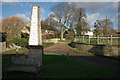
Milestone, Bredon
The obelisk milestone in Bredon dates from 1808. The distances read: Upton 6, Pershore 7, Evesham 12, Tewkesbury 3, Winchcombe 10, Cheltenham 11.
Image: © Philip Halling
Taken: 21 Jan 2007
0.07 miles
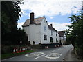
8

The Old Cider House, Bredon
An 18th century painted brick house, Listed Grade II.
Image: © Chris Allen
Taken: 17 Jan 2022
0.07 miles
9

Avonside Cottage, Bredon
The long single storey building is a former range of cottages that is now one dwelling. Dating from the 17/18th century and Listed Grade II. The 1808 obelisk in the foreground is also Listed Grade II.
Image: © Chris Allen
Taken: 17 Jan 2022
0.08 miles
10

Obelisk, Bredon
Dated 1808 and with distances on the one face. Listed Grade II.
Image: © Chris Allen
Taken: 17 Jan 2022
0.08 miles