IMAGES TAKEN NEAR TO
Main Road, TEWKESBURY, GL20 7EG
Introduction
This page details the photographs taken nearby to Main Road, GL20 7EG by members of the Geograph project.
The Geograph project started in 2005 with the aim of publishing, organising and preserving representative images for every square kilometre of Great Britain, Ireland and the Isle of Man.

There are currently over 7.5m images from over14,400 individuals and you can help contribute to the project by visiting https://www.geograph.org.uk
Image Map
Images are licensed for reuse under creativecommons.org/licenses/by-sa/2.0
Notes
- Clicking on the map will re-center to the selected point.
- The higher the marker number, the further away the image location is from the centre of the postcode.
Image Listing (259 Images Found)
Images are licensed for reuse under creativecommons.org/licenses/by-sa/2.0
Image
Details
Distance
1

Lodge to Manor House, Bredon
Early 19th century painted brick lodge. The gate posts are claimed to be inverted cannon barrels. Listed Grade II.
Image: © Chris Allen
Taken: 17 Jan 2022
0.00 miles
2
Lodge house to Bredon Manor
Early 19th century lodge house with inverted cannons for gateposts.
Image: © Philip Pankhurst
Taken: 30 Jun 2018
0.00 miles
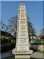
4
The Bredon Milepost
Dating from 1808.
Image: © Philip Pankhurst
Taken: 30 Jun 2018
0.01 miles
5
The Bredon Milepost, 1808
Giving distances to all of the major local settlements, but sadly not the direction of travel.
Image: © Philip Pankhurst
Taken: 30 Jun 2018
0.01 miles
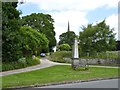
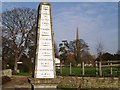
6
Old Milestone by B4080, Tewkesbury Road; on green at junction leading to Church
The Milestone is located on triangle of grass on the North side of the road. Parish of Bredon (Wychavon District). Metal plate attached to stone post, erected by the parish in the 19th Century. An earlier photograph can be found here: https://www.geograph.org.uk/photo/6072722
Inscription reads:-
1808 / BREDON / UPTON / 6 Miles / PERSHORE / 7 Miles / EVESHAM / 12 Miles / TEWKESBURY / 3 Miles / WINCHCOMB / 10 Miles / CHELTENHAM / 11 Miles
Grade II listed. List Entry Number: 1319647 https://historicengland.org.uk/listing/the-list/list-entry/1319647
Milestone Society National ID: WO_ZBED
Image: © Roadside Relics
Taken: 23 Mar 2022
0.01 miles
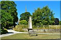
7
Old Milestone, B4080, High Street, Bredon
The milestone is located at the junction leading to the church, on the triangle of grass on the north side of road. Parish of Bredon (Wychavon District). Metal plate attached to obelisk stone post, erected by the parish in the 19th century.
Inscription reads:- : 1808 / BREDON / UPTON / 6 Miles / PERSHORE / 7 Miles / EVESHAM / 12 Miles / TEWKESBURY / 3 Miles / WINCHCOMB / 10 Miles / CHELTENHAM / 11 Miles :
Grade II Listed, List Entry Number: 1319647
https://historicengland.org.uk/listing/the-list/list-entry/1319647
Milestone Society National ID: WO_ZBED
Image: © A Rosevear
Taken: 6 Oct 2004
0.02 miles
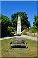
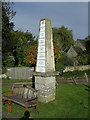
8

Obelisk, Bredon
Dated 1808 and with distances on the one face. Listed Grade II.
Image: © Chris Allen
Taken: 17 Jan 2022
0.02 miles
10

Outbuilding to the east of Old Thatch Cottage, Bredon
Although described as a small outbuilding this appears to be a dwelling in its own right. It is 17th century and timber framed with stone foundations and a tiled roof. Listed Grade II. Seen from the public right of way.
Image: © Chris Allen
Taken: 17 Jan 2022
0.02 miles