IMAGES TAKEN NEAR TO
Bredon Road, TEWKESBURY, GL20 7EB
Introduction
This page details the photographs taken nearby to Bredon Road, GL20 7EB by members of the Geograph project.
The Geograph project started in 2005 with the aim of publishing, organising and preserving representative images for every square kilometre of Great Britain, Ireland and the Isle of Man.

There are currently over 7.5m images from over14,400 individuals and you can help contribute to the project by visiting https://www.geograph.org.uk
Image Map
Images are licensed for reuse under creativecommons.org/licenses/by-sa/2.0
Notes
- Clicking on the map will re-center to the selected point.
- The higher the marker number, the further away the image location is from the centre of the postcode.
Image Listing (8 Images Found)
Images are licensed for reuse under creativecommons.org/licenses/by-sa/2.0
Image
Details
Distance
1
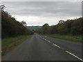
Long straight at Mitton Lodge
The road has just passed into Worcestershire.
Image: © Peter Whatley
Taken: 12 Oct 2011
0.07 miles
2
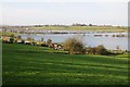
View to The Mythe
View across the flooded Avon valley towards the Mythe Hill near Tewkesbury.
Image: © Philip Halling
Taken: 31 Dec 2015
0.11 miles
3
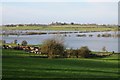
Flooded Avon and The Mythe
View over a flooded Avon valley to The Mythe, a ridge between the River Avon and Severn.
Image: © Philip Halling
Taken: 31 Dec 2015
0.11 miles
4

The flooded Avon and Mythe Hill
View over the flooded Avon meadows to Mythe Hill. Since the removal last year of the railway embankment of the former Ashchurch to Great Malvern railway line the Mythe Waterworks can be seen on the left. I photographed the same view in January 2007 when the railway embankment was extant and obscuring the waterworks. See: Image]
Image: © Philip Halling
Taken: 19 Jan 2014
0.13 miles
5
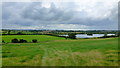
View over the Avon valley
In square is a flooded gravel pit, part of the Croft Farm Leisure and Water Park.
The Malvern Hills on the skyline.
Image: © Jonathan Billinger
Taken: 21 Aug 2012
0.15 miles
6
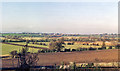
Westward across Avon Valley near Bredon's Hardwick to Twyning
View westward from B4080 just south of Bredon's Hardwick to (L-to-R):- Shuthonger, Twyning Church End, Twyning Hill End; Malvern Hills on horizon.
Image: © Ben Brooksbank
Taken: 14 Nov 1988
0.19 miles
7

The flood Avon at Bredon's Hardwick
View across the flooded Avon valley from the B4080 near Bredon's Hardwick. Twyning is on the other side of the valley with the Malvern Hills on the horizon.
Image: © Philip Halling
Taken: 19 Jan 2014
0.21 miles
8

Flooded River Avon at Bredon's Hardwick
View across the flooded Avon valley from the B4080 near Bredon's Hardwick. Twyning is on the other side of the valley with the Malvern Hills on the horizon.
Image: © Philip Halling
Taken: 19 Jan 2014
0.21 miles