IMAGES TAKEN NEAR TO
School Lane, TEWKESBURY, GL20 6EU
Introduction
This page details the photographs taken nearby to School Lane, GL20 6EU by members of the Geograph project.
The Geograph project started in 2005 with the aim of publishing, organising and preserving representative images for every square kilometre of Great Britain, Ireland and the Isle of Man.

There are currently over 7.5m images from over14,400 individuals and you can help contribute to the project by visiting https://www.geograph.org.uk
Image Map
Images are licensed for reuse under creativecommons.org/licenses/by-sa/2.0
Notes
- Clicking on the map will re-center to the selected point.
- The higher the marker number, the further away the image location is from the centre of the postcode.
Image Listing (144 Images Found)
Images are licensed for reuse under creativecommons.org/licenses/by-sa/2.0
Image
Details
Distance
1
Houses on the road to Naunton
A row of modern houses link the old council houses to Ripple village centre.
Viewed from the vantage point on top of the old refuse tip.
The Malvern Hills can be seen in the distance.
Image: © Bob Embleton
Taken: 14 Mar 2010
0.01 miles
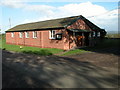
3
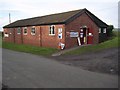
Ripple's Polling Station
Ripple Village Hall serving as a polling station for the 2015 General Election.
Image: © Philip Halling
Taken: 7 May 2015
0.11 miles
4
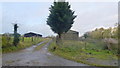
Line of footpath
Heading north from Ripple towards Stratfordbridge.
Image: © Jonathan Billinger
Taken: 12 Nov 2012
0.13 miles
5
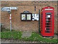
Signpost and telephone box
Signpost and telephone box in the centre of Ripple and yes there is still a telephone inside. Rare in 2021.
Image: © Philip Halling
Taken: 2 Mar 2021
0.18 miles
6
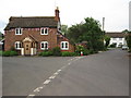
Jubilee bunting in Ripple
A cottage in the centre of the village of Ripple with Jubilee bunting hung across it.
Image: © Philip Halling
Taken: 25 Jun 2012
0.18 miles
7
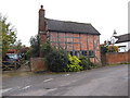
Timber Cottage, Ripple
C17 timber-framed cottage in Ripple. It is Grade II listed.
Image: © Eirian Evans
Taken: 18 Oct 2014
0.18 miles
8

Houses in Ripple
Houses the centre of the village of Ripple. The redbrick house on the right has a clock on the front wall Image
Image: © Philip Halling
Taken: 2 Mar 2021
0.18 miles
9

Ripple; St Mary's Church
The view looking back from St Marys
Image: © Michael Garlick
Taken: 5 Feb 2012
0.19 miles
10
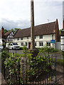
Old Wayside Cross
The Market Cross, a central cross with an old shaft, base & steps. Set on the green in Ripple parish. Grade II Listed https://historicengland.org.uk/listing/the-list/list-entry/1302510. See https://www.geograph.org.uk/article/Wayside-Crosses-Ripple-Worcestershire - a list of images of the wayside, village & market crosses in the village .
Milestone Society National ID: WOMH_RIP02
Image: © Mr Red
Taken: 7 May 2019
0.19 miles