IMAGES TAKEN NEAR TO
Longdon, TEWKESBURY, GL20 6AN
Introduction
This page details the photographs taken nearby to GL20 6AN by members of the Geograph project.
The Geograph project started in 2005 with the aim of publishing, organising and preserving representative images for every square kilometre of Great Britain, Ireland and the Isle of Man.

There are currently over 7.5m images from over14,400 individuals and you can help contribute to the project by visiting https://www.geograph.org.uk
Image Map
Images are licensed for reuse under creativecommons.org/licenses/by-sa/2.0
Notes
- Clicking on the map will re-center to the selected point.
- The higher the marker number, the further away the image location is from the centre of the postcode.
Image Listing (7 Images Found)
Images are licensed for reuse under creativecommons.org/licenses/by-sa/2.0
Image
Details
Distance
1
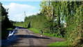
Welcoming canine at Broadfield Farm
The lane from Slades Green to Guller's End.
Image: © Jonathan Billinger
Taken: 29 Aug 2012
0.01 miles
2
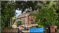
Elmwood Barn
https://historicengland.org.uk/listing/the-list/list-entry/1273909?section=official-list-entry
Image: © Sandy Gerrard
Taken: 28 Apr 2024
0.16 miles
3
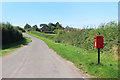
An Isolated Post Box
Standing by a road junction, this box serves a handful of nearby farms and houses without being particularly near any of them.
Image: © Des Blenkinsopp
Taken: 24 Aug 2019
0.18 miles
4
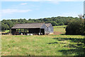
Cowsheds at Orchard Farm
A footpath heads into the fields past various farm buildings.
Image: © Des Blenkinsopp
Taken: 24 Aug 2019
0.20 miles
5
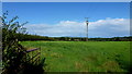
View east from Piper's End
Bredon Hill in the distance.
Image: © Jonathan Billinger
Taken: 29 Aug 2012
0.22 miles
6
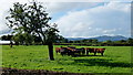
Cattle at Piper's End farm
The M50 (heard but not seen) between the end of the field and the Malvern Hills.
Image: © Jonathan Billinger
Taken: 29 Aug 2012
0.22 miles
7
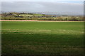
Slades Green
Slades Green viewed from Bushley, the Malvern Hills are on the horizon.
Image: © Philip Halling
Taken: 2 Mar 2008
0.23 miles