IMAGES TAKEN NEAR TO
Gloucester Road, TEWKESBURY, GL20 5SY
Introduction
This page details the photographs taken nearby to Gloucester Road, GL20 5SY by members of the Geograph project.
The Geograph project started in 2005 with the aim of publishing, organising and preserving representative images for every square kilometre of Great Britain, Ireland and the Isle of Man.

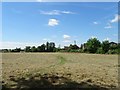
There are currently over 7.5m images from over14,400 individuals and you can help contribute to the project by visiting https://www.geograph.org.uk
Image Map
Images are licensed for reuse under creativecommons.org/licenses/by-sa/2.0
Notes
- Clicking on the map will re-center to the selected point.
- The higher the marker number, the further away the image location is from the centre of the postcode.
Image Listing (110 Images Found)
Images are licensed for reuse under creativecommons.org/licenses/by-sa/2.0
Image
Details
Distance
1

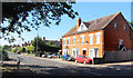
Aldi, Tewkesbury
This Aldi store on Gloucester Road occupies the former site of a car sales business.
Image: © Philip Halling
Taken: 3 May 2014
0.02 miles
3
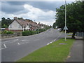
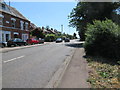
Gloucester Road
Looking south-east along the main southern route out of the town. The specimen trees behind the houses to the left are in the large town cemetery.
Image: © Trevor Rickard
Taken: 5 Jun 2008
0.05 miles
4
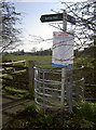
Public right of way to the battle
Tewkesbury's Battle Trail extends from the south at Margaret's Camp to the town and Abbey. Here the path crosses part of the main site (it is thought) of the 1471 battle at Lincoln Green.
The public notice refers to the uneasy movements taken over some of this greenery: plans have been proposed to build on it, but local opposition has been roused to prevent it.
Image: © Neil Owen
Taken: 10 Mar 2014
0.06 miles
5
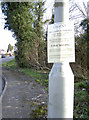
Calling for local resistance!
The fields south of Tewkesbury are the site of the last battle of the War of the Roses, on 4th May, 1471. Some of that land has been built upon but much still remains untouched by the bulldozers.
The Governors of Tewkesbury School have put the land up for sale and are attracting interest from developers. However, the Tewkesbury Battlefield Society are trying to raise a counter bid in order to stop any changes to the existing access. A similar tender for housing in 1996 was eventually rejected by the Government.
Image: © Neil Owen
Taken: 10 Mar 2014
0.06 miles
6
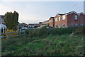
New housing on a battlefield
Inevitable expansion of a town. One of the roads is called Battle Road in acknowledgement.
Image: © Bill Boaden
Taken: 31 Oct 2014
0.07 miles
7
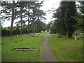
Tewkesbury Cemetery - 2
Looking north-west along the perimeter path. This very large cemetery is managed by the borough council, and is located on higher ground above and well to the south of the town centre. There are many mature trees.
Image: © Trevor Rickard
Taken: 5 Jun 2008
0.07 miles
8
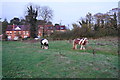
Horses near Gloucester Road
Grazing near the former battlefield.
Image: © Bill Boaden
Taken: 31 Oct 2014
0.07 miles
10
Crossing the battlefield on the Battlefield Trail
The Battle of Tewkesbury on 4th May 1471 was the decisive battle of the Wars of the Roses when the army of Margaret of Anjou (for Henry VI) was beaten by Lancastrian King Edward IV. The large site is threatened by housing development.
Image: © John M
Taken: 8 Jul 2017
0.09 miles