IMAGES TAKEN NEAR TO
St. Marys Lane, TEWKESBURY, GL20 5SJ
Introduction
This page details the photographs taken nearby to St. Marys Lane, GL20 5SJ by members of the Geograph project.
The Geograph project started in 2005 with the aim of publishing, organising and preserving representative images for every square kilometre of Great Britain, Ireland and the Isle of Man.

There are currently over 7.5m images from over14,400 individuals and you can help contribute to the project by visiting https://www.geograph.org.uk
Image Map
Images are licensed for reuse under creativecommons.org/licenses/by-sa/2.0
Notes
- Clicking on the map will re-center to the selected point.
- The higher the marker number, the further away the image location is from the centre of the postcode.
Image Listing (2010 Images Found)
Images are licensed for reuse under creativecommons.org/licenses/by-sa/2.0
Image
Details
Distance
1
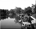
River Avon at Tewkesbury
A selection of light craft moored here.
Image: © Dr Neil Clifton
Taken: 29 Jul 1977
0.01 miles
3
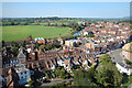
View from the Abbey Tower
Buildings along Church Street, with the River Avon beyond.
Image: © Des Blenkinsopp
Taken: 25 Aug 2019
0.02 miles
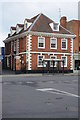
5
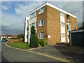
Small block of flats
A small block of flats on St Mary's Lane in Tewkesbury, based on the architectural style the building appears to date from the late 1960s or early 1970s.
Image: © Philip Halling
Taken: 6 Sep 2016
0.02 miles
6
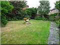
Friends Burial Ground
This former Friends Burial Ground dating from 1660 off St Mary's Lane in Tewkesbury is now a private garden which is open to the public on some days.
Image: © Philip Halling
Taken: 6 Aug 2020
0.02 miles
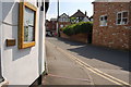
7
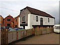
The Old Chandlery, St Mary's Lane, Tewkesbury
"Saint Mary’s Lane is within the area of medieval settlement of
Tewkesbury and as such is a site of archaeological interest. A standing
building on the site is Grade II listed and is noted by the Gloucestershire
Site and Monument Record (SMR 8016) as an 18th century tannery drying
house." from an Archaeology Data Service PDF.
I believe it has been redeveloped since the document was produced.
Image: © Jeff Gogarty
Taken: 17 Dec 2015
0.02 miles
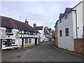
8
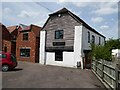
The Old Chandlery
The Old Chandlery, now converted into residential accommodation. This building is Grade II listed and described as 'General boat store/warehouse, formerly tannery drying house.' in its listing description. See: https://historicengland.org.uk/listing/the-list/list-entry/1201297
Image: © Philip Halling
Taken: 1 Jun 2021
0.02 miles
9
Church Street Practice Tewkesbury
Tewkesbury's Doctors surgery, Church Street Practice occupies this Queen Anne style house dating from around 1800.
Image: © Philip Halling
Taken: 22 Jan 2012
0.03 miles
10
![Tewkesbury houses [23]](https://s2.geograph.org.uk/geophotos/06/88/13/6881310_2b04ff63_120x120.jpg)
Tewkesbury houses [23]
This fine house, number 77 Church Street, is now a veterinary surgery. Built in the early 18th century in brick with stone dressings and a tile roof. The house has an unusual plan, with a courtyard to one side providing access. There a fine gate piers at the entrance to the courtyard. There are some fine original internal features and fittings. Listed, grade II*, with details at: https://historicengland.org.uk/listing/the-list/list-entry/1280534
The market town of Tewkesbury is sited at the confluence of the River Severn and the River Avon, some 9 miles north of Gloucester, close to the border with Worcestershire. Founded in Saxon times, the town thrived and there are many medieval and Tudor buildings including Tewkesbury Abbey, bought by the townspeople to use as their parish church. One of the decisive battles of the Wars of the Roses was the Battle of Tewkesbury, which took place on 4 May 1471.
Image: © Michael Dibb
Taken: 18 May 2021
0.03 miles