IMAGES TAKEN NEAR TO
St. Marys Road, TEWKESBURY, GL20 5SE
Introduction
This page details the photographs taken nearby to St. Marys Road, GL20 5SE by members of the Geograph project.
The Geograph project started in 2005 with the aim of publishing, organising and preserving representative images for every square kilometre of Great Britain, Ireland and the Isle of Man.

There are currently over 7.5m images from over14,400 individuals and you can help contribute to the project by visiting https://www.geograph.org.uk
Image Map
Images are licensed for reuse under creativecommons.org/licenses/by-sa/2.0
Notes
- Clicking on the map will re-center to the selected point.
- The higher the marker number, the further away the image location is from the centre of the postcode.
Image Listing (1907 Images Found)
Images are licensed for reuse under creativecommons.org/licenses/by-sa/2.0
Image
Details
Distance
1
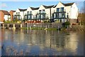
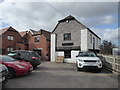
Apartments reflected in a flooded Mill Avon
Much of the land overlooking Mill Avon has been redeveloped in recent years, replacing former industrial buildings and warehouses.
Image: © Philip Halling
Taken: 24 Feb 2022
0.01 miles
2
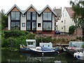
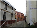
Tannery Mews
Tannery Mews viewed from across the Mill Avon. The tower of Tewkesbury Abbey can be seen in the background.
Image: © Philip Halling
Taken: 6 Aug 2020
0.01 miles
3
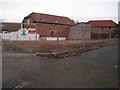
Redevelopment site, St Mary's Lane
Redevelopment site on St Mary's Lane beside the Mill Avon in Tewkesbury. See this same site in 2019 after it has been redeveloped Image
Image: © Philip Halling
Taken: 21 Dec 2013
0.01 miles
4
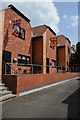
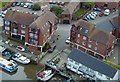
Modern houses in Tewkesbury
Modern houses on St Mary's Road in Tewkesbury. Note the banners with coats of arms, each represents one of the aristocrats who fought at the battle of Tewkesbury in 1471. See the site when it was about to be redeveloped Image]
Image: © Philip Halling
Taken: 8 Jul 2019
0.01 miles
5
St Mary's Road, Tewkesbury (3)
Turning away from the river.
Image: © Jeff Gogarty
Taken: 17 Dec 2015
0.02 miles
6
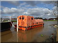
A very full River Avon, Tewkesbury
In fact it was so full that the road behind the photographer was impassable due to flood waters. The orange vessel appears to have been a former lifeboat from a larger vessel. I have now been informed it was in fact a lifeboat from an oil rig.
Image: © Chris Allen
Taken: 3 Mar 2020
0.02 miles
7
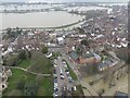
On the Avon at Tewkesbury
Public access to the River Avon at Tewkesbury. Taken at 550ft from G-BYOV
Image: © Ken Ballinger
Taken: 30 Sep 2000
0.02 miles
8
Twekesbury Partly Flooded
Twekesbury Ham Flooded.
Image: © Peter Randall-Cook
Taken: 27 Feb 2024
0.02 miles
9
The Old Chandlery, Tewkesbury
The white building with weatherboarding is labelled as "The Old Chandlery". It appears to be a genuine old building in this grouping. The others appear to be modern pastiches.
Image: © Chris Allen
Taken: 3 Mar 2020
0.02 miles
10
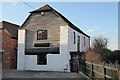
Former Tannery drying house
Today this building has been converted in residential accommodation but in the past this Grade II listed building https://historicengland.org.uk/listing/the-list/list-entry/1201297?section=official-list-entry has been a general boat store/warehouse and before that a tannery drying house.
Image: © Philip Halling
Taken: 2 Mar 2023
0.02 miles