IMAGES TAKEN NEAR TO
Back Of Mount Pleasant, TEWKESBURY, GL20 5RD
Introduction
This page details the photographs taken nearby to Back Of Mount Pleasant, GL20 5RD by members of the Geograph project.
The Geograph project started in 2005 with the aim of publishing, organising and preserving representative images for every square kilometre of Great Britain, Ireland and the Isle of Man.

There are currently over 7.5m images from over14,400 individuals and you can help contribute to the project by visiting https://www.geograph.org.uk
Image Map
Images are licensed for reuse under creativecommons.org/licenses/by-sa/2.0
Notes
- Clicking on the map will re-center to the selected point.
- The higher the marker number, the further away the image location is from the centre of the postcode.
Image Listing (915 Images Found)
Images are licensed for reuse under creativecommons.org/licenses/by-sa/2.0
Image
Details
Distance
1
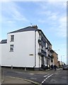
House at the junction of Chance Street and Barton Road, Tewkesbury
This building, a short terrace of three houses, is noteworthy for the balconies on two floors and the steps with railings from the street
Image: © David Smith
Taken: 31 Dec 2015
0.02 miles
3

Barton House
Guest house on the junction of Barton Road and Chance Street.
Image: © Pauline E
Taken: 7 Nov 2008
0.03 miles
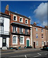
4

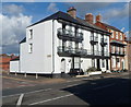
Houses on Barton Street
This large white houses on the corner of Barton Street and Chance Street with its ironwork verandas is likely to date from around the 1830s.
Image: © Philip Halling
Taken: 11 Sep 2010
0.03 miles
5
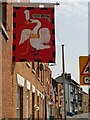
Buckingham battle flag on a house in Tewkesbury
Image: © Jeff Gogarty
Taken: 23 Jul 2021
0.03 miles
6
Barton House B&B, Tewkesbury
Guesthouse viewed across the A438 Barton Road.
Image: © Jaggery
Taken: 14 Oct 2012
0.03 miles
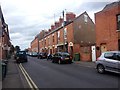
7

Chance Street, Tewkesbury
Chance Street in Tewkesbury is lined with nineteenth century terrace houses.
Image: © Philip Halling
Taken: 11 Sep 2010
0.03 miles
9
Corner of Chance Street and Barton Road, Tewkesbury
Chance Street on the left marks the change of name from the A438 Barton Street behind the camera to the A438 Barton Road ahead.
Image: © Jaggery
Taken: 14 Oct 2012
0.03 miles
10
![Tewkesbury houses [55]](https://s1.geograph.org.uk/geophotos/06/88/83/6888313_15c0d313_120x120.jpg)
Tewkesbury houses [55]
Numbers 1 and 3 Barton Terrace, Barton Road, is a terrace of two houses, formerly three. Built in the mid 19th century in rendered brick under a slate roof. There are some fine decorative wood trellis and balconies. Listed, grade II, with details at: https://historicengland.org.uk/listing/the-list/list-entry/1204640
The market town of Tewkesbury is sited at the confluence of the River Severn and the River Avon, some 9 miles north of Gloucester, close to the border with Worcestershire. Founded in Saxon times, the town thrived and there are many medieval and Tudor buildings including Tewkesbury Abbey, bought by the townspeople to use as their parish church. One of the decisive battles of the Wars of the Roses was the Battle of Tewkesbury, which took place on 4 May 1471.
Image: © Michael Dibb
Taken: 18 May 2021
0.03 miles