IMAGES TAKEN NEAR TO
Barton Street, TEWKESBURY, GL20 5PP
Introduction
This page details the photographs taken nearby to Barton Street, GL20 5PP by members of the Geograph project.
The Geograph project started in 2005 with the aim of publishing, organising and preserving representative images for every square kilometre of Great Britain, Ireland and the Isle of Man.

There are currently over 7.5m images from over14,400 individuals and you can help contribute to the project by visiting https://www.geograph.org.uk
Image Map
Images are licensed for reuse under creativecommons.org/licenses/by-sa/2.0
Notes
- Clicking on the map will re-center to the selected point.
- The higher the marker number, the further away the image location is from the centre of the postcode.
Image Listing (1920 Images Found)
Images are licensed for reuse under creativecommons.org/licenses/by-sa/2.0
Image
Details
Distance
1
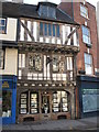
Half-timbered building in Tewkesbury
This attractive half-timbered building is just on the High Street, near the Cross in Tewkesbury. The building is now an estate agent, however, it used to be a traditional fishmonger.
Image: © Philip Halling
Taken: 25 Nov 2008
0.01 miles
2
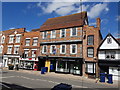
Detail of buildings
Detail of buildings on Barton Street in Tewkesbury.
Image: © Philip Halling
Taken: 15 Dec 2012
0.01 miles
3
![Tewkesbury buildings [60]](https://s1.geograph.org.uk/geophotos/06/88/32/6883273_19015001_120x120.jpg)
Tewkesbury buildings [60]
Number 8 Barton Street is an early 18th century building, a former public house, The Duke of York, which closed in 1999. Built in brick under a tile roof. Listed, grade II, with details at: https://historicengland.org.uk/listing/the-list/list-entry/1281036
The market town of Tewkesbury is sited at the confluence of the River Severn and the River Avon, some 9 miles north of Gloucester, close to the border with Worcestershire. Founded in Saxon times, the town thrived and there are many medieval and Tudor buildings including Tewkesbury Abbey, bought by the townspeople to use as their parish church. One of the decisive battles of the Wars of the Roses was the Battle of Tewkesbury, which took place on 4 May 1471.
Image: © Michael Dibb
Taken: 18 May 2021
0.01 miles
4
![Tewkesbury buildings [61]](https://s2.geograph.org.uk/geophotos/06/88/40/6884026_7c2b8f10_120x120.jpg)
Tewkesbury buildings [61]
Numbers 9 and 10 Barton Street are a late 18th century pair of houses with shops. Built in brick with a tile roof and tripartite arched windows. The shopfronts are 19th century. Listed, grade II, with details at: https://historicengland.org.uk/listing/the-list/list-entry/1201180
The market town of Tewkesbury is sited at the confluence of the River Severn and the River Avon, some 9 miles north of Gloucester, close to the border with Worcestershire. Founded in Saxon times, the town thrived and there are many medieval and Tudor buildings including Tewkesbury Abbey, bought by the townspeople to use as their parish church. One of the decisive battles of the Wars of the Roses was the Battle of Tewkesbury, which took place on 4 May 1471.
Image: © Michael Dibb
Taken: 18 May 2021
0.01 miles
5
![Tewkesbury buildings [62]](https://s3.geograph.org.uk/geophotos/06/88/40/6884027_08b8508b_120x120.jpg)
Tewkesbury buildings [62]
Number 11 Barton Street is a late 18th or early 19th house with shop. Built in brick with a tile roof with a through passage to the left. The shopfront is 19th century. Listed, grade II, with details at: https://historicengland.org.uk/listing/the-list/list-entry/1204759
The market town of Tewkesbury is sited at the confluence of the River Severn and the River Avon, some 9 miles north of Gloucester, close to the border with Worcestershire. Founded in Saxon times, the town thrived and there are many medieval and Tudor buildings including Tewkesbury Abbey, bought by the townspeople to use as their parish church. One of the decisive battles of the Wars of the Roses was the Battle of Tewkesbury, which took place on 4 May 1471.
Image: © Michael Dibb
Taken: 18 May 2021
0.01 miles
6
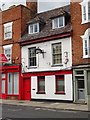
The Old Duke of York - Barton Street
The public house closed in 1999 Imageand after conversion and extension to rear was an accountants. More recently it was home to a community drug and alcohol service with the property to the left in similar colour scheme. Both are now on the market as the county wide service transferred to a new provider on 1st January 2017.
Image: © John M
Taken: 8 Jul 2017
0.01 miles
7
![Tewkesbury buildings [59]](https://s1.geograph.org.uk/geophotos/06/88/32/6883249_5692c827_120x120.jpg)
Tewkesbury buildings [59]
Number 7 Barton Street, a house with a shop in a row, is an early 19th century building in brick with a tile roof. The shopfront is 19th century. There is a through passage to the left. Listed, grade II, with details at: https://historicengland.org.uk/listing/the-list/list-entry/1201179
The market town of Tewkesbury is sited at the confluence of the River Severn and the River Avon, some 9 miles north of Gloucester, close to the border with Worcestershire. Founded in Saxon times, the town thrived and there are many medieval and Tudor buildings including Tewkesbury Abbey, bought by the townspeople to use as their parish church. One of the decisive battles of the Wars of the Roses was the Battle of Tewkesbury, which took place on 4 May 1471.
Image: © Michael Dibb
Taken: 18 May 2021
0.01 miles
8
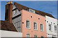
The Mustard House, 13 and 14 Barton Street, Tewkesbury
Originally C15 or C16 timber framed building.
Image: © Jeff Gogarty
Taken: 20 Aug 2020
0.01 miles
9
![Tewkesbury buildings [63]](https://s0.geograph.org.uk/geophotos/06/88/40/6884028_abf5fca3_120x120.jpg)
Tewkesbury buildings [63]
Number 12 Barton Street is a 17th century timber framed building, refronted in brick in the mid or late 18th century. There is a long rear wing with access from the through passage under number 13 Barton Street. The shopfront is 20th century. Listed, grade II, with details at: https://historicengland.org.uk/listing/the-list/list-entry/1282817
The market town of Tewkesbury is sited at the confluence of the River Severn and the River Avon, some 9 miles north of Gloucester, close to the border with Worcestershire. Founded in Saxon times, the town thrived and there are many medieval and Tudor buildings including Tewkesbury Abbey, bought by the townspeople to use as their parish church. One of the decisive battles of the Wars of the Roses was the Battle of Tewkesbury, which took place on 4 May 1471.
Image: © Michael Dibb
Taken: 18 May 2021
0.01 miles
10
![Tewkesbury buildings [64]](https://s0.geograph.org.uk/geophotos/06/88/40/6884032_fde4bcb6_120x120.jpg)
Tewkesbury buildings [64]
The Mustard House, numbers 13 and 14 Barton Street (nearest the camera) are a pair of 15th or 16th century houses, now used as offices. Timber framed with brick nogging, double jettied to the street, all under a concrete tile, mansard roof. The front has been rebuilt with new timbers, but there is much original internal and exposed framing. There is a lower rear wing and the double shopfront is 19th century. Some 17th century internal fittings remain. The name is a reminder of the earlier importance of Tewkesbury in the production of 'mustard balls'. Listed, grade II, with details at: https://historicengland.org.uk/listing/the-list/list-entry/1281040
To the right of The Mustard House is number 15 Barton Street, a very narrow house built in brick with a tile roof in the early 19th century. Listed, grade II, with details at: https://historicengland.org.uk/listing/the-list/list-entry/1201181
The market town of Tewkesbury is sited at the confluence of the River Severn and the River Avon, some 9 miles north of Gloucester, close to the border with Worcestershire. Founded in Saxon times, the town thrived and there are many medieval and Tudor buildings including Tewkesbury Abbey, bought by the townspeople to use as their parish church. One of the decisive battles of the Wars of the Roses was the Battle of Tewkesbury, which took place on 4 May 1471.
Image: © Michael Dibb
Taken: 18 May 2021
0.01 miles