IMAGES TAKEN NEAR TO
High Street, TEWKESBURY, GL20 5JZ
Introduction
This page details the photographs taken nearby to High Street, GL20 5JZ by members of the Geograph project.
The Geograph project started in 2005 with the aim of publishing, organising and preserving representative images for every square kilometre of Great Britain, Ireland and the Isle of Man.

There are currently over 7.5m images from over14,400 individuals and you can help contribute to the project by visiting https://www.geograph.org.uk
Image Map
Images are licensed for reuse under creativecommons.org/licenses/by-sa/2.0
Notes
- Clicking on the map will re-center to the selected point.
- The higher the marker number, the further away the image location is from the centre of the postcode.
Image Listing (1358 Images Found)
Images are licensed for reuse under creativecommons.org/licenses/by-sa/2.0
Image
Details
Distance
1
Tewkesbury post office
Located at 99-100 High Street. The overhanging upper storeys, though providing a degree of shelter for pedestrians, give the ground floor shops a somewhat inconspicuous appearance.
Image: © Jaggery
Taken: 14 Oct 2012
0.01 miles
2
The site of Tewkesbury Railway Station
Tewkesbury's first railway station stood on the High Street and opened in 1840. This station was on a branch line connecting Ashchurch Station on the main Bristol to Birmingham line with Tewkesbury and the river quay on the Severn. The station closed in 1864 when a second station was built in the town on the new Ashchurch to Malvern railway. This first station was demolished in 1929 but for some inexplicable reason a pillar seen here on the left was left standing.
Image: © Philip Halling
Taken: 18 Jul 2020
0.01 miles
3

The Anchor, Tewkesbury
A pub on the corner of High Street and Quay Street
Image: © Jonathan Billinger
Taken: 20 Oct 2008
0.01 miles
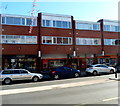
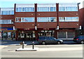
4
Tewkesbury High Street
In the 1960s this part of Tewkesbury High Street was redeveloped. In the 1970s the English architectural historian, Alec Clifton-Taylor, presented a BBC television series called 'Six English Towns'; one of the towns was Tewkesbury and he wasn't very complimentary about this High Street development.
Image: © Philip Halling
Taken: 10 Nov 2012
0.01 miles
5
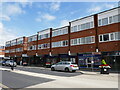
Untypical Tewkesbury
These shops and flats date from 1972.
Image: © Jonathan Thacker
Taken: 11 Jun 2024
0.01 miles
6
![Tewkesbury buildings [135]](https://s2.geograph.org.uk/geophotos/06/89/15/6891538_c3dc294b_120x120.jpg)
Tewkesbury buildings [135]
Number 104 High Street is a 17th century building, refronted in the early to mid 19th century. The front is brick, the rest timber framed under a tile roof. The set back attic was rebuilt in the 20th century. The shopfront is 20th century. Listed, for group value, grade II, with details at: https://historicengland.org.uk/listing/the-list/list-entry/1025076
The market town of Tewkesbury is sited at the confluence of the River Severn and the River Avon, some 9 miles north of Gloucester, close to the border with Worcestershire. Founded in Saxon times, the town thrived and there are many medieval and Tudor buildings including Tewkesbury Abbey, bought by the townspeople to use as their parish church. One of the decisive battles of the Wars of the Roses was the Battle of Tewkesbury, which took place on 4 May 1471.
Image: © Michael Dibb
Taken: 18 May 2021
0.01 miles
7
![Tewkesbury buildings [136]](https://s3.geograph.org.uk/geophotos/06/89/15/6891539_79895216_120x120.jpg)
Tewkesbury buildings [136]
Number 105 High Street has an early 19th century front, probably on an earlier structure. The shopfront is late 19th century. Listed, grade II, with details at: https://historicengland.org.uk/listing/the-list/list-entry/1201261
The market town of Tewkesbury is sited at the confluence of the River Severn and the River Avon, some 9 miles north of Gloucester, close to the border with Worcestershire. Founded in Saxon times, the town thrived and there are many medieval and Tudor buildings including Tewkesbury Abbey, bought by the townspeople to use as their parish church. One of the decisive battles of the Wars of the Roses was the Battle of Tewkesbury, which took place on 4 May 1471.
Image: © Michael Dibb
Taken: 18 May 2021
0.01 miles
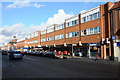
8
From wine to coffee in Tewkesbury High Street
At the mid-October 2012 date of this view, Costa coffee shop at 95-96 High Street
was in premises formerly occupied by Wine Rack (wine, beer and spirits retailers).
A branch of Blockbuster is on the left. Woody's fruit and vegetables shop is on the right.
Image: © Jaggery
Taken: 14 Oct 2012
0.01 miles
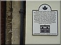
9
![Tewkesbury features [7]](https://s3.geograph.org.uk/geophotos/06/89/15/6891531_5fbcf96c_120x120.jpg)
Tewkesbury features [7]
This limestone column, between numbers 102 and 103 High Street, is all that remains of Tewkesbury's first railway station. See the details on the accompanying plaque Image
The market town of Tewkesbury is sited at the confluence of the River Severn and the River Avon, some 9 miles north of Gloucester, close to the border with Worcestershire. Founded in Saxon times, the town thrived and there are many medieval and Tudor buildings including Tewkesbury Abbey, bought by the townspeople to use as their parish church. One of the decisive battles of the Wars of the Roses was the Battle of Tewkesbury, which took place on 4 May 1471.
Image: © Michael Dibb
Taken: 18 May 2021
0.01 miles
10
![Tewkesbury features [8]](https://s2.geograph.org.uk/geophotos/06/89/15/6891534_15b1925f_120x120.jpg)
Tewkesbury features [8]
The plaque accompanying the column seen at Image
The market town of Tewkesbury is sited at the confluence of the River Severn and the River Avon, some 9 miles north of Gloucester, close to the border with Worcestershire. Founded in Saxon times, the town thrived and there are many medieval and Tudor buildings including Tewkesbury Abbey, bought by the townspeople to use as their parish church. One of the decisive battles of the Wars of the Roses was the Battle of Tewkesbury, which took place on 4 May 1471.
Image: © Michael Dibb
Taken: 18 May 2021
0.01 miles