IMAGES TAKEN NEAR TO
Harbourside, TEWKESBURY, GL20 5DT
Introduction
This page details the photographs taken nearby to Harbourside, GL20 5DT by members of the Geograph project.
The Geograph project started in 2005 with the aim of publishing, organising and preserving representative images for every square kilometre of Great Britain, Ireland and the Isle of Man.

There are currently over 7.5m images from over14,400 individuals and you can help contribute to the project by visiting https://www.geograph.org.uk
Image Map
Images are licensed for reuse under creativecommons.org/licenses/by-sa/2.0
Notes
- Clicking on the map will re-center to the selected point.
- The higher the marker number, the further away the image location is from the centre of the postcode.
Image Listing (228 Images Found)
Images are licensed for reuse under creativecommons.org/licenses/by-sa/2.0
Image
Details
Distance
1
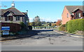
Harbourside, Tewkesbury
Harbourside leads from Bredon Road to Tewkesbury Marina.
Image: © Jaggery
Taken: 14 Oct 2012
0.02 miles
2
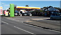
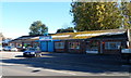
Shell and Budgens, Tewkesbury
Shell filling station and Budgens shop on the corner of Bredon Road and Carrant Road.
Image: © Jaggery
Taken: 14 Oct 2012
0.03 miles
4
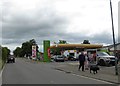
Shell filling station, Bredon Road, Tewkesbury
Image: © David Smith
Taken: 16 Jun 2018
0.05 miles
6
Handyman Centre, Tewkesbury
Located in a 40 metre long building in Bredon Road.
Image: © Jaggery
Taken: 14 Oct 2012
0.05 miles
8
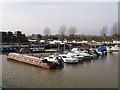
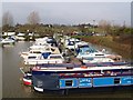
Yachts in Tewkesbury Marina
Viewed from Harbourside looking towards the NE corner of the marina.
There is an outlet to the River Avon in the SW corner.
Image: © Jaggery
Taken: 14 Oct 2012
0.07 miles
9
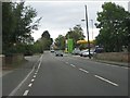
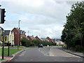
B4080 at the old railway bridge
The bridge parapets mark the course of the former railway between Ashchurch and Malvern. A classic example of the hopelessly uneconomic British country branch line, it was closed to passengers in two stages (1952 & 1961), both well before the 1960s Labour governments' decimation of the railway network.
Image: © Peter Whatley
Taken: 12 Oct 2011
0.07 miles
10
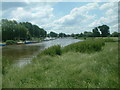
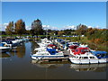
Approaching Tewkesbury on the Avon
Taken from the footpath from Twyning at a point nearing the Marina in Tewkesbury.
Image: © Mark Walton
Taken: 7 Jun 2008
0.07 miles