IMAGES TAKEN NEAR TO
Manns Court, High Street, TEWKESBURY, GL20 5BP
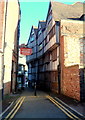
Introduction
This page details the photographs taken nearby to Manns Court, High Street, GL20 5BP by members of the Geograph project.
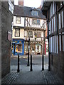
The Geograph project started in 2005 with the aim of publishing, organising and preserving representative images for every square kilometre of Great Britain, Ireland and the Isle of Man.

There are currently over 7.5m images from over14,400 individuals and you can help contribute to the project by visiting https://www.geograph.org.uk
Image Map
Images are licensed for reuse under creativecommons.org/licenses/by-sa/2.0
Notes
- Clicking on the map will re-center to the selected point.
- The higher the marker number, the further away the image location is from the centre of the postcode.
Image Listing (2168 Images Found)
Images are licensed for reuse under creativecommons.org/licenses/by-sa/2.0
Image
Details
Distance
1
Tolsey Lane
Tolsey Lane's junction with Tewkesbury High Street.
Image: © Philip Halling
Taken: 7 Mar 2011
0.00 miles
2
One lane, two names, Tewkesbury
This is the SE end of an ancient lane from the edge
of the River Avon to High Street (ahead).
The name plates show GUEST LANE (OR) TOLZEY LANE.
One source states that this lane had an earlier name, Salters Lane.
Image: © Jaggery
Taken: 14 Oct 2012
0.00 miles
3
Narrow SE end of Tolsey Lane, Tewkesbury
Looking towards High Street. A black metal post blocks anything wider than a motorbike.
Vehicular access to the far end of the lane is from the road named Back of Avon.
The large red name sign shows Malcolm J. Presland FUNERAL DIRECTORS.
Image: © Jaggery
Taken: 14 Oct 2012
0.00 miles
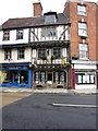
4

1-2 High Street, Tewkesbury
An attractive early C18th pair, both with some pizazz in the parapet department. No. 1's clock is dated 1883. Grade II* listed.
No. 1 was the premises of Malcolm Presland (funeral directors) while no. 2 was empty and to let.
Image: © Stephen Richards
Taken: 18 Aug 2015
0.00 miles
5

Tolsey Lane, Tewkesbury
Looking along Tolsey Lane (or Guest Lane) from the High Street - reverse view to Image
Image: © Pierre Terre
Taken: 17 May 2009
0.01 miles
6
![Tewkesbury buildings [167]](https://s1.geograph.org.uk/geophotos/06/89/36/6893657_8c4c00c2_120x120.jpg)
Tewkesbury buildings [167]
Number 150 High Street is a narrow fronted building. The front is late 18th century on an earlier structure. There are two Venetian windows on the upper floors above a 20th century shopfront. Listed, grade II, with details at: https://historicengland.org.uk/listing/the-list/list-entry/1187221
The market town of Tewkesbury is sited at the confluence of the River Severn and the River Avon, some 9 miles north of Gloucester, close to the border with Worcestershire. Founded in Saxon times, the town thrived and there are many medieval and Tudor buildings including Tewkesbury Abbey, bought by the townspeople to use as their parish church. One of the decisive battles of the Wars of the Roses was the Battle of Tewkesbury, which took place on 4 May 1471.
Image: © Michael Dibb
Taken: 18 May 2021
0.01 miles
7
![Tewkesbury buildings [168]](https://s2.geograph.org.uk/geophotos/06/89/36/6893662_03d302c6_120x120.jpg)
Tewkesbury buildings [168]
Number 151 High Street is a narrow fronted building in a row. The front is early 19th century on an earlier structure. The shopfront is late 19th century. Listed, grade II, with details at: https://historicengland.org.uk/listing/the-list/list-entry/1201273
The market town of Tewkesbury is sited at the confluence of the River Severn and the River Avon, some 9 miles north of Gloucester, close to the border with Worcestershire. Founded in Saxon times, the town thrived and there are many medieval and Tudor buildings including Tewkesbury Abbey, bought by the townspeople to use as their parish church. One of the decisive battles of the Wars of the Roses was the Battle of Tewkesbury, which took place on 4 May 1471.
Image: © Michael Dibb
Taken: 18 May 2021
0.01 miles
8
![Tewkesbury buildings [169]](https://s3.geograph.org.uk/geophotos/06/89/36/6893667_b80f4d29_120x120.jpg)
Tewkesbury buildings [169]
Number 152 High Street is a narrow fronted building in a row. The brick front is late 18th century on an earlier structure. The shopfront is 19th century. Listed, grade II, with details at: https://historicengland.org.uk/listing/the-list/list-entry/1187323
The market town of Tewkesbury is sited at the confluence of the River Severn and the River Avon, some 9 miles north of Gloucester, close to the border with Worcestershire. Founded in Saxon times, the town thrived and there are many medieval and Tudor buildings including Tewkesbury Abbey, bought by the townspeople to use as their parish church. One of the decisive battles of the Wars of the Roses was the Battle of Tewkesbury, which took place on 4 May 1471.
Image: © Michael Dibb
Taken: 18 May 2021
0.01 miles
10
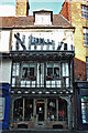
155 High Street, Tewkesbury
Grade II* Listed late 15th early 16th century timber framed house built as a pair with number 154. Many windows have early glass including one scratched 'Mary Logos 1738'.
Image: © Jo and Steve Turner
Taken: 19 Jun 2005
0.01 miles