IMAGES TAKEN NEAR TO
Westgate Street, GLOUCESTER, GL1 9SP
Introduction
This page details the photographs taken nearby to Westgate Street, GL1 9SP by members of the Geograph project.
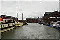
The Geograph project started in 2005 with the aim of publishing, organising and preserving representative images for every square kilometre of Great Britain, Ireland and the Isle of Man.

There are currently over 7.5m images from over14,400 individuals and you can help contribute to the project by visiting https://www.geograph.org.uk
Image Map
Images are licensed for reuse under creativecommons.org/licenses/by-sa/2.0
Notes
- Clicking on the map will re-center to the selected point.
- The higher the marker number, the further away the image location is from the centre of the postcode.
Image Listing (1364 Images Found)
Images are licensed for reuse under creativecommons.org/licenses/by-sa/2.0
Image
Details
Distance
1
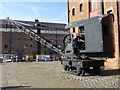
Track mounted crane
Track mounted crane in Gloucester Docks.
Image: © Philip Halling
Taken: 23 Feb 2019
0.00 miles
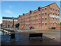
2
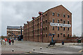
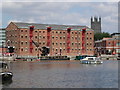
North Warehouse
Former warehouse, built 1826-7. Grade II listed - see www.historicengland.org.uk/listing/the-list/list-entry/1245466.
In the background is Lock Warehouse, built in 1834 overlooking the lock that connects the docks with the East Channel of the River Severn. Also grade II listed - see www.historicengland.org.uk/listing/the-list/list-entry/1245608.
Image: © Ian Capper
Taken: 16 Mar 2019
0.01 miles
3
North Warehouse, Gloucester Quays
This warehouse was built in 1826. This is the oldest of the warehouses at the quays, dating from the opening of the canal. By the 1980s the building was derelict and in a dangerous condition but it has been restored and now forms the head office of Gloucester City Council.
Image: © Eirian Evans
Taken: 24 Mar 2010
0.01 miles
4
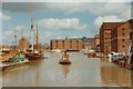
Gloucester docks
Superficially, this view (taken from the old lift bridge in summer 1993) hasn't changed a lot in the intervening years. However, the warehouses are now enjoying a new lease of life as apartment blocks, whereas here they're derelict. The eagle eyed among you may spot a Citroen Dyane parked up on the left of the shot, and you don't see too many of those around these days either!
See Image for a contemporary comparison view.
Image: © John Winder
Taken: Unknown
0.01 miles
5
Gloucester Docks twenty years later
See my earlier photo at http://www.geograph.org.uk/photo/3854330 for a comparison shot of how this view looked in 1993. The National Waterways Museum is now housed in a building just out of shot to the right and there are fewer commercial boats around these days.
Image: © John Winder
Taken: 2 Mar 2014
0.01 miles
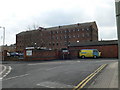
6
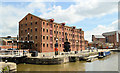
North Warehouse, Gloucester Docks
Now the headquarters of Gloucester City Council, North Warehouse is the oldest of the magnificent dock warehouses, having been completed in 1827 to the designs of Bartin Haigh of Liverpool.
Image: © Philip Pankhurst
Taken: 16 Jun 2014
0.01 miles
7
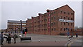
North Warehouse, Gloucester Docks
The North Warehouse is the oldest warehouse at Gloucester Docks, built in 1826, i.e. just before the Gloucester and Sharpness Canal was opened in April 1827 to enable seagoing ships of the time to reach Gloucester. By 1829, the warehouse was already working at full capacity. Originally floor space was rented by many small businesses according to their individual needs for storage of various materials. However, following the repeal of the corn laws in 1846, the Canal Company decided to let the two halves of the building to two corn merchants as sole occupiers. The building continued to be used in its entirety until 1962, when the upper floors were condemned as derelict. The ground floor and cellars were in use until 1975. After a decade of abandonment, the warehouse was refurbished and turned into office accommodation for Gloucester City Council in 1986.
To the left of the sign saying "North Warehouse" can be seen the bell installed to signal the begin and end of shifts for the warehouse workers. It is known as the Atlas Bell as the original bell was taken from a ship of that name. https://www.gloucesterdocks.me.uk/gloucester/warehouses/northwarehouse.htm
A steam crane similar http://www.geograph.org.uk/photo/6095381to the ones which would once have operated in Gloucester Docks can be seen on North Quay in front of the building.
Image: © Rudi Winter
Taken: 16 Mar 2019
0.01 miles
8
North and Lock Warehouses, The Docks, Gloucester
The North Warehouse was the first to be built, in 1826-27 to the designs of Bartin Haigh. Lock was built in 1834 and altered in the 1920s. Grade II listed.
The restoration of Gloucester docks is a rare C20th conservation success story, largely because of the sheer number of surviving buildings but also the sympathetic way in which they have been treated. There is no gimmicky cladding, and the area has not, at least yet, been swamped by incongruous modern tat. Around fifteen warehouses, mostly built for storing grain, survive (eight have been demolished) and have been converted to offices, including for the city council, or tourist attractions.
Image: © Stephen Richards
Taken: 18 May 2015
0.01 miles
9
Gloucester city council offices North warehouse
The restored North warehouse is now used by the Gloucester council as offices. Towering up behind is Gloucester cathedral. Around the dock there are new homes, shops and restaurants.
Image: © Vincent Jones
Taken: 7 Aug 2005
0.01 miles
10
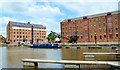
Lock and North Warehouses, Gloucester Docks
The converted warehouses at the North end of the Dock, where the lock gives access to the River Severn and the rest of England's waterway system.
Image: © Philip Pankhurst
Taken: 16 Jun 2014
0.01 miles