IMAGES TAKEN NEAR TO
Westgate Street, GLOUCESTER, GL1 9SN
Introduction
This page details the photographs taken nearby to Westgate Street, GL1 9SN by members of the Geograph project.
The Geograph project started in 2005 with the aim of publishing, organising and preserving representative images for every square kilometre of Great Britain, Ireland and the Isle of Man.

There are currently over 7.5m images from over14,400 individuals and you can help contribute to the project by visiting https://www.geograph.org.uk
Image Map
Images are licensed for reuse under creativecommons.org/licenses/by-sa/2.0
Notes
- Clicking on the map will re-center to the selected point.
- The higher the marker number, the further away the image location is from the centre of the postcode.
Image Listing (1402 Images Found)
Images are licensed for reuse under creativecommons.org/licenses/by-sa/2.0
Image
Details
Distance
1
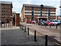
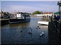
Gloucester City Council, Herbert Warehouse
Gloucester City Council in the converted Herbert Warehouse at Gloucester Docks.
Image: © Philip Halling
Taken: 31 May 2018
0.00 miles
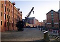
2
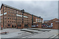
Herbert, Kimberley and Phillpotts Warehouses
The end of three former warehouses, all built in 1846 and now used as offices by Gloucester City Council. Nearest is Herbert Warehouse, then Kimberley Warehouse and beyond is Phillpotts Warehouse. All are grade II listed - see www.historicengland.org.uk/listing/the-list/list-entry/1245605, www.historicengland.org.uk/listing/the-list/list-entry/1245606 and www.historicengland.org.uk/listing/the-list/list-entry/www.historicengland.org.uk/listing/the-list/list-entry/1245606respectively.
Image: © Ian Capper
Taken: 16 Mar 2019
0.00 miles
3

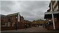
Geographers at Gloucester Docks (14th Anniversary Meet-up)
To celebrate the 14th anniversary of the Geograph Project a group of Geographers met up in the historic city of Gloucester. After lunch at the Fountain Inn, Philip Halling led a tour of some interesting parts of the city including the rejuvenated docks. This photograph was taken there outside Herbert Warehouse, which is now used as offices by Gloucester City Council.
Left to right:- Pete Chadwick, Alan Murray-Rust, Philip Halling, Basher Eyre, Julian Osley, Rudi Winter, Ian Capper, Robin Stott, David Purchase, Julia, Stephen McKay and Martin Phelan.
Image: © L S Wilson
Taken: 16 Mar 2019
0.00 miles
4
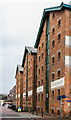
Victoria and Herbert Warehouses
Two former warehouses, Victoria Warehouse on the left (built in 1849) and Herbert Warehouse on the right (built in 1846). Herbert Warehouse is now used by Gloucester City Council. Both are grade II listed - see www.historicengland.org.uk/listing/the-list/list-entry/1245470 and www.historicengland.org.uk/listing/the-list/list-entry/1245605 respectively.
Image: © Ian Capper
Taken: 16 Mar 2019
0.01 miles
5

The Atlas Bell, North Warehouse
Once used to signal start and finish times for the dockers, the bell came from the Atlas, launched in 1812, broken up in 1832. She made several journeys to China and India for the East India Company. The bell also spent 45 years at Shepperdine as a navigation aid in fog.
Image: © Pauline E
Taken: 19 Oct 2008
0.01 miles
8
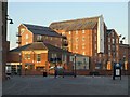
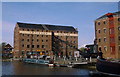
Buildings at Gloucester Docks
The low building is part of the dock office. Behind rises Priday's Mill, built in 1850 as the City Flour Mills, and the setting for a celebrated legal case, Hadley v Baxendale http://www.gloucesterdocks.me.uk/studies/pridaysmill.htm . The building has been converted into apartments.
Image: © Derek Harper
Taken: 22 Jun 2010
0.02 miles
10
Snap(ped)
We're all photographing each other during a walk to celebrate Geograph's 14th birthday
Image: © Basher Eyre
Taken: 16 Mar 2019
0.02 miles