IMAGES TAKEN NEAR TO
Forthampton, GLOUCESTER, GL19 4RG
Introduction
This page details the photographs taken nearby to GL19 4RG by members of the Geograph project.
The Geograph project started in 2005 with the aim of publishing, organising and preserving representative images for every square kilometre of Great Britain, Ireland and the Isle of Man.

There are currently over 7.5m images from over14,400 individuals and you can help contribute to the project by visiting https://www.geograph.org.uk
Image Map
Images are licensed for reuse under creativecommons.org/licenses/by-sa/2.0
Notes
- Clicking on the map will re-center to the selected point.
- The higher the marker number, the further away the image location is from the centre of the postcode.
Image Listing (48 Images Found)
Images are licensed for reuse under creativecommons.org/licenses/by-sa/2.0
Image
Details
Distance
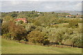
1
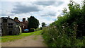
Bridleway on Cork's Hill
Passing properties on the way to following the Severn bank to Lower Lode.
Image: © Jonathan Billinger
Taken: 31 Aug 2012
0.01 miles
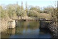
2
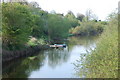
Former main channel of the River Severn at Upper Lode
Soon to be an oxbow lake!
Image: © Roger Davies
Taken: 9 Apr 2011
0.05 miles
3
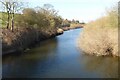
Former course of the River Severn
Former course of the River Severn at Upper Lode.
Image: © Philip Halling
Taken: 2 Mar 2023
0.05 miles
4
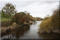
River Severn backwater
A partial loop dead-end behind the Upper Lode lock on the river Severn.
Now an SSSI and a private fishing area.
Image: © Bob Embleton
Taken: 2 Nov 2010
0.05 miles
5
View over Upper Lode
View over Upper Lode to Mythe Hill, with Bredon Hill on the horizon. The Telford designed Mythe Bridge crossing the River Severn can be seen below Mythe Hill on the right.
Image: © Philip Halling
Taken: 11 Sep 2011
0.07 miles
6
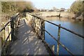
Footbridge beside the River Severn
Footbridge crossing the old course of the River Severn. The river was realigned here in the 1840s when a weir and lock were constructed here at Upper Lode.
Image: © Philip Halling
Taken: 2 Mar 2023
0.09 miles
7
Footbridge at Upper Lode
Footbridge crossing the old course of the River Severn. The river was realigned here in the 1840s when a weir and lock were constructed here at Upper Lode.
Image: © Philip Halling
Taken: 2 Mar 2023
0.09 miles
8
Footbridge at Upper Lode
A footbridge carrying a riverside footpath over the old course of the river.
Image: © Philip Halling
Taken: 3 Jul 2016
0.10 miles
9
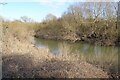
The old River Severn
Until the weir and lock was constructed in the 1840s at Upper Lode, this was the course of the River Severn. This is almost like an oxbow lake, though at the southern end it is still connected to the main course of the river.
Image: © Philip Halling
Taken: 2 Mar 2023
0.10 miles
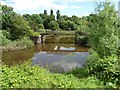
10
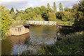
Footbridge at Upper Lode
This footbridge at Upper Lode carries a footpath over the old course of the River Severn.
Image: © Philip Halling
Taken: 11 Sep 2011
0.10 miles