IMAGES TAKEN NEAR TO
Long Green, GLOUCESTER, GL19 4QJ
Introduction
This page details the photographs taken nearby to Long Green, GL19 4QJ by members of the Geograph project.
The Geograph project started in 2005 with the aim of publishing, organising and preserving representative images for every square kilometre of Great Britain, Ireland and the Isle of Man.

There are currently over 7.5m images from over14,400 individuals and you can help contribute to the project by visiting https://www.geograph.org.uk
Image Map
Images are licensed for reuse under creativecommons.org/licenses/by-sa/2.0
Notes
- Clicking on the map will re-center to the selected point.
- The higher the marker number, the further away the image location is from the centre of the postcode.
Image Listing (5 Images Found)
Images are licensed for reuse under creativecommons.org/licenses/by-sa/2.0
Image
Details
Distance
1
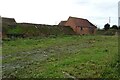
Farm buildings at Downend
Farm buildings at Downend beside the A438. These farm building have the appearance of redundancy and may be awaiting conversion.
Image: © Philip Halling
Taken: 10 Nov 2020
0.03 miles
2
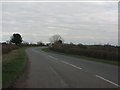
The A438 passing Downend
Farm buildings at Downend beside the A438. These farm building have the appearance of redundancy and may be awaiting conversion.
Image: © Philip Halling
Taken: 10 Nov 2020
0.03 miles
3
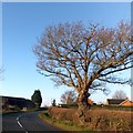
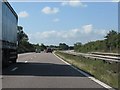
Bare tree by the A438 in Downend
The A438 cuts between the handful of buildings at Downend with the majority of farm buildings on the left (south)
Image: © David Smith
Taken: 13 Jan 2014
0.05 miles