IMAGES TAKEN NEAR TO
Eldersfield Marsh, GLOUCESTER, GL19 4PH
Introduction
This page details the photographs taken nearby to Eldersfield Marsh, GL19 4PH by members of the Geograph project.
The Geograph project started in 2005 with the aim of publishing, organising and preserving representative images for every square kilometre of Great Britain, Ireland and the Isle of Man.

There are currently over 7.5m images from over14,400 individuals and you can help contribute to the project by visiting https://www.geograph.org.uk
Image Map
Images are licensed for reuse under creativecommons.org/licenses/by-sa/2.0
Notes
- Clicking on the map will re-center to the selected point.
- The higher the marker number, the further away the image location is from the centre of the postcode.
Image Listing (5 Images Found)
Images are licensed for reuse under creativecommons.org/licenses/by-sa/2.0
Image
Details
Distance
1
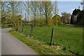
Bridleway near Hardwick Farm
A bridleway on Eldersfield Marsh passing balsam poplar trees near Hardwick Farm.
Image: © Philip Halling
Taken: 17 Apr 2021
0.14 miles
2
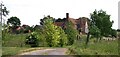
Hardwick Court
At the end of a long no through road. Probably around the site of a deserted mediaeval village of Hardwick Green
Image: © Bob Embleton
Taken: 19 Jun 2005
0.17 miles
3
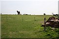
Electric fence over a public bridleway
Just one of several obstructions encountered yesterday when trying to follow public rights of way.
A waymarking post (with no waymarking signs!) has been positioned in the ground near Hardwick Farm.
Paths 506 and 583 meet Bridleway 590 somewhere near here.
Image: © Bob Embleton
Taken: 24 Apr 2010
0.20 miles
4
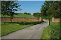
Road to Hooze Farm
Hooze Farm is at the end of a no through road at Hardwick Green.
Image: © Philip Halling
Taken: 25 Aug 2007
0.21 miles
5
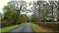
Lane to Hardwick Green
Mature trees at Marshland up ahead.
Image: © Jonathan Billinger
Taken: 19 Nov 2015
0.24 miles