IMAGES TAKEN NEAR TO
Corse Lawn, GLOUCESTER, GL19 4PE
Introduction
This page details the photographs taken nearby to GL19 4PE by members of the Geograph project.
The Geograph project started in 2005 with the aim of publishing, organising and preserving representative images for every square kilometre of Great Britain, Ireland and the Isle of Man.

There are currently over 7.5m images from over14,400 individuals and you can help contribute to the project by visiting https://www.geograph.org.uk
Image Map
Images are licensed for reuse under creativecommons.org/licenses/by-sa/2.0
Notes
- Clicking on the map will re-center to the selected point.
- The higher the marker number, the further away the image location is from the centre of the postcode.
Image Listing (7 Images Found)
Images are licensed for reuse under creativecommons.org/licenses/by-sa/2.0
Image
Details
Distance
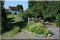
1
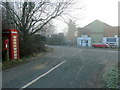
Garage, phone box and post box
At the junction of the lane from Swinley and the B4211.
The left hand side of the image is in square, the MG and most of the garage building is in SO8331.
Image: © Jonathan Billinger
Taken: 8 Feb 2011
0.02 miles
3
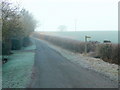
Lane to Swinley
A footpath heads right (north) across fields to Mitre Farm.
Image: © Jonathan Billinger
Taken: 8 Feb 2011
0.05 miles
4
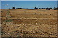
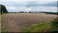
Stubble field at Swinley Green
Partly baled stubble field at Swinley Green. The roof of Mitre farm can be seen on the horizon.
Image: © Philip Halling
Taken: 25 Aug 2007
0.12 miles
5
Arable land to the east of Swinley Court
Mitre Farm in the autumnal distance.
Image: © Jonathan Billinger
Taken: 13 Oct 2016
0.20 miles
7
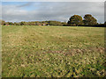
Pastures, Corse Lawn
From the Chaceley road.
Image: © Pauline E
Taken: 7 Nov 2008
0.25 miles