IMAGES TAKEN NEAR TO
Corse Lawn, GLOUCESTER, GL19 4NG
Introduction
This page details the photographs taken nearby to GL19 4NG by members of the Geograph project.
The Geograph project started in 2005 with the aim of publishing, organising and preserving representative images for every square kilometre of Great Britain, Ireland and the Isle of Man.

There are currently over 7.5m images from over14,400 individuals and you can help contribute to the project by visiting https://www.geograph.org.uk
Image Map
Images are licensed for reuse under creativecommons.org/licenses/by-sa/2.0
Notes
- Clicking on the map will re-center to the selected point.
- The higher the marker number, the further away the image location is from the centre of the postcode.
Image Listing (11 Images Found)
Images are licensed for reuse under creativecommons.org/licenses/by-sa/2.0
Image
Details
Distance
1
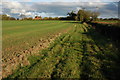
Field to the west of Mitre farm
The farmhouse to Mitre Farm can be seen over the hedge.
Image: © Philip Halling
Taken: 28 Oct 2007
0.05 miles
2
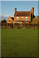
Mitre Farm
Farmhouse at Mitre Farm, Cold Elm.
Image: © Philip Halling
Taken: 28 Oct 2007
0.05 miles

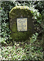
4

Old Milestone by the B4211, Swinley Green, Eldersfield parish
Modern metal plate attached to stone post by the B4211, in parish of ELDERSFIELD (MALVERN HILLS District), Forthampton, Swinley Green, 150 yds South of bend, on the verge, on Southeast side of road. Erected by the Upton-upon-Severn turnpike trust in the 19th century.
Inscription reads:-
ELDERSFIELD
UPTON
6
GLOSTER
10
MILES
Milestone Society National ID: WO_USGL06.
Image: © J Higgins
Taken: 1 May 2007
0.19 miles
5
Old Milestone by the B4211, Swinley Green, Eldersfield parish
Modern metal plate attached to stone post by the B4211, in parish of ELDERSFIELD (MALVERN HILLS District), Forthampton, Swinley Green, 150 yds South of bend, on the verge, on Southeast side of road. Erected by the Upton-upon-Severn turnpike trust in the 19th century.
Inscription reads:-
ELDERSFIELD
UPTON
6
GLOSTER
10
MILES
Milestone Society National ID: WO_USGL06.
Image: © Roadside Relics
Taken: 12 Aug 2021
0.19 miles
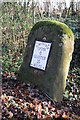
6
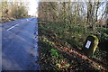
Milestone beside the B4211
One of a series of milestones beside the B4211 between Upton-upon-Severn and the county boundary at Eldersfield. This one is near Forthampton though the plate reads Eldersfield.
Image: © Philip Halling
Taken: 24 Dec 2013
0.19 miles
7
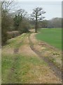
Footpath and field headland
Footpath and field headland near Mitre Farm at Swinley Green.
Image: © Philip Halling
Taken: 13 Jan 2018
0.20 miles
8
Milestone on the B4211 near Forthampton
One of a series of milestones on the B4211 between Upton-upon-Severn and the county boundary at Eldersfield. This one is near Forthampton though the plate reads Eldersfield.
Image: © Philip Halling
Taken: 24 Dec 2013
0.20 miles
9
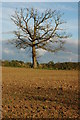
Dead oak tree near Mitre Farm
Dead oak tree viewed from the footpath to the north of Mitre Farm.
Image: © Philip Halling
Taken: 28 Oct 2007
0.23 miles
10
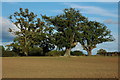
Oak trees near Mitre Farm
Large oak trees in a field beside the footpath to the north of Mitre Farm.
Image: © Philip Halling
Taken: 28 Oct 2007
0.23 miles