IMAGES TAKEN NEAR TO
Corse Lawn, GLOUCESTER, GL19 4ND
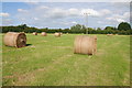
Introduction
This page details the photographs taken nearby to GL19 4ND by members of the Geograph project.
The Geograph project started in 2005 with the aim of publishing, organising and preserving representative images for every square kilometre of Great Britain, Ireland and the Isle of Man.

There are currently over 7.5m images from over14,400 individuals and you can help contribute to the project by visiting https://www.geograph.org.uk
Image Map
Images are licensed for reuse under creativecommons.org/licenses/by-sa/2.0
Notes
- Clicking on the map will re-center to the selected point.
- The higher the marker number, the further away the image location is from the centre of the postcode.
Image Listing (15 Images Found)
Images are licensed for reuse under creativecommons.org/licenses/by-sa/2.0
Image
Details
Distance
1

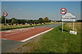
The B4211 approaching the Gloucestershire border
The B4211 crossing Corse Lawn and approaching the Gloucestershire border.
Image: © Philip Halling
Taken: 24 Dec 2013
0.12 miles
2
Hay bales in a field near Eldersfield
Haymaking has been delayed this summer due to the poor weather.
Image: © Philip Halling
Taken: 18 Aug 2012
0.13 miles
3
Corse Lawn
The southern boundary of the parish of Corse Lawn is also the county boundary between the counties of Gloucestershire and Worcestershire.
Image: © Philip Halling
Taken: 25 Aug 2007
0.16 miles
4
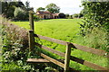
Stile near Hallings Farm
A stile on a footpath at Hallings Farm near Eldersfield. Going back into the eighteenth and nineteenth centuries my ancestors lived in this area on the north Gloucestershire border with Worcestershire and I wonder if there is some connection with one of my ancestors and this farm.
Image: © Philip Halling
Taken: 18 Aug 2012
0.16 miles
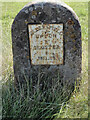
5
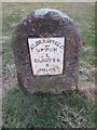
Milestone - Gloucester 8
There is an Ordnance Survey cut mark which marks a point 24.8869m above mean sea level below the plaque.
Image: © Adrian Dust
Taken: 7 Mar 2015
0.18 miles
6
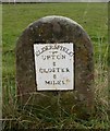
Old Milestone by the B4211, Eldersfield parish
Metal plate attached to stone post by the B4211, in parish of ELDERSFIELD (MALVERN HILLS District), 120m North of post box, middle of large green, on open grass, on South side of road. Erected by the Upton-upon-Severn turnpike trust in the 19th century.
Inscription reads:-
ELDERSFIELD
{line}
UPTON
8
GLOSTER
8
MILES
Carved benchmark on lower face.
Grade II listed.
List Entry Number: 1157093 https://historicengland.org.uk/listing/the-list/list-entry/1157093
Milestone Society National ID: WO_USGL08
Image: © Mike Faherty
Taken: 13 Nov 2009
0.18 miles
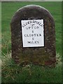
7
Old Milestone by the B4211, Eldersfield parish
Metal plate attached to stone post by the B4211, in parish of ELDERSFIELD (MALVERN HILLS District), 120m North of post box, middle of large green, on open grass, on South side of road. Erected by the Upton-upon-Severn turnpike trust in the 19th century.
Inscription reads:-
ELDERSFIELD
{line}
UPTON
8
GLOSTER
8
MILES
Carved benchmark on lower face.
Grade II listed.
List Entry Number: 1157093 https://historicengland.org.uk/listing/the-list/list-entry/1157093
Milestone Society National ID: WO_USGL08
Image: © Roadside Relics
Taken: 20 Sep 2021
0.18 miles
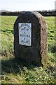
8
Corse Lawn, milestone
Milestone with finely cast plate, bearing the legend "ELDERSFIELD/UPTON/8/GLOSTER/8/MILES". The wide open space on both sides of the road is common land.
Image: © Mike Faherty
Taken: 13 Nov 2009
0.18 miles
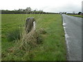
9
Milestone on the B4211 on Corse Lawn
One of a series of milestones on the B4211 between Upton-upon-Severn and the county boundary at Eldersfield. This one is the nearest to the county boundary. There is an Ordnance Survey cut mark below the plaque.
Image: © Philip Halling
Taken: 24 Dec 2013
0.19 miles
10
Eldersfield Milestone
This milestone is one of a series that appears along the B4211.
Image: © Ant Collis
Taken: 8 Nov 2007
0.19 miles