IMAGES TAKEN NEAR TO
Tirley, GLOUCESTER, GL19 4HQ
Introduction
This page details the photographs taken nearby to GL19 4HQ by members of the Geograph project.
The Geograph project started in 2005 with the aim of publishing, organising and preserving representative images for every square kilometre of Great Britain, Ireland and the Isle of Man.

There are currently over 7.5m images from over14,400 individuals and you can help contribute to the project by visiting https://www.geograph.org.uk
Image Map
Images are licensed for reuse under creativecommons.org/licenses/by-sa/2.0
Notes
- Clicking on the map will re-center to the selected point.
- The higher the marker number, the further away the image location is from the centre of the postcode.
Image Listing (9 Images Found)
Images are licensed for reuse under creativecommons.org/licenses/by-sa/2.0
Image
Details
Distance
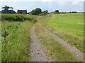
2
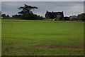
Cumberwood Farm, Tirley
Cumberwood Farm stands on a bank overlooking the Severn flood plain to the north of the village of Tirley. According to census records this was the home of my great-great-grandparents in the 19th century.
Image: © Philip Halling
Taken: 22 Sep 2007
0.02 miles
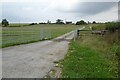
3
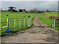
Great Cumberwood
Entrance to Great Cumberwood Farm viewed from the passing country road.
Image: © Philip Halling
Taken: 12 Nov 2020
0.13 miles
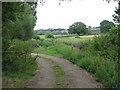
4

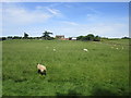
Grass field near Great Cumberwood Farm
Corse Grove in the distance.
Image: © Jonathan Thacker
Taken: 23 Jun 2018
0.14 miles
6
Cumberwood Farm
Cumberwood Farm near Tirley.
Image: © Philip Halling
Taken: 2 Jul 2021
0.14 miles
7
Great Cumberwood Farm
Entrance to Great Cumberwood Farm in Tirley.
Image: © Philip Halling
Taken: 3 Sep 2022
0.16 miles
9

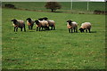
Grass field and willow trees near Tirley
Image: © Jonathan Thacker
Taken: 23 Jun 2018
0.24 miles