IMAGES TAKEN NEAR TO
Tirley, GLOUCESTER, GL19 4HF
Introduction
This page details the photographs taken nearby to GL19 4HF by members of the Geograph project.
The Geograph project started in 2005 with the aim of publishing, organising and preserving representative images for every square kilometre of Great Britain, Ireland and the Isle of Man.

There are currently over 7.5m images from over14,400 individuals and you can help contribute to the project by visiting https://www.geograph.org.uk
Image Map
Images are licensed for reuse under creativecommons.org/licenses/by-sa/2.0
Notes
- Clicking on the map will re-center to the selected point.
- The higher the marker number, the further away the image location is from the centre of the postcode.
Image Listing (7 Images Found)
Images are licensed for reuse under creativecommons.org/licenses/by-sa/2.0
Image
Details
Distance
1
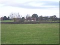
Little Sandpits Farm
Viewed from the south east.
Image: © Bob Embleton
Taken: 29 Nov 2005
0.08 miles
3
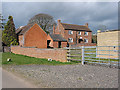
Cattle in an old orchard
At Great Sandpits Farm.
Image: © Jonathan Billinger
Taken: 6 Aug 2015
0.10 miles
4
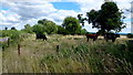
Cattle in the orchard
At Little Sandpits Farm, the cattle enjoy a springlike day.
Image: © Pauline E
Taken: 7 Mar 2008
0.11 miles
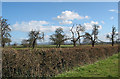
5
View to Corse Hill
Looking south from near Sandpits.
Image: © Jonathan Billinger
Taken: 6 Aug 2015
0.13 miles
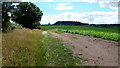
6
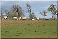
Orchard near Little Sandpits Farm
The distant outline of the Cotswold Ridge can be seen on the horizon.
Image: © Pauline E
Taken: 7 Mar 2008
0.15 miles
7
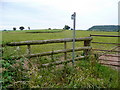
Footpath to Tirley
Heading south-east from near Great Sandpits.
Flat-topped, wooded Corse Hill can be seen over to the right.
Image: © Jonathan Billinger
Taken: 8 Jul 2010
0.20 miles