IMAGES TAKEN NEAR TO
Hill Farm Lane, GLOUCESTER, GL19 4EZ
Introduction
This page details the photographs taken nearby to Hill Farm Lane, GL19 4EZ by members of the Geograph project.
The Geograph project started in 2005 with the aim of publishing, organising and preserving representative images for every square kilometre of Great Britain, Ireland and the Isle of Man.

There are currently over 7.5m images from over14,400 individuals and you can help contribute to the project by visiting https://www.geograph.org.uk
Image Map
Images are licensed for reuse under creativecommons.org/licenses/by-sa/2.0
Notes
- Clicking on the map will re-center to the selected point.
- The higher the marker number, the further away the image location is from the centre of the postcode.
Image Listing (23 Images Found)
Images are licensed for reuse under creativecommons.org/licenses/by-sa/2.0
Image
Details
Distance
1
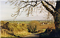
NE view from Corse Wood Hill
Similar to my Image], but to the left - to Tewkesbury (6 miles) and on left horizon Bredon Hill (12 miles).
Image: © Ben Brooksbank
Taken: 13 Nov 1988
0.04 miles
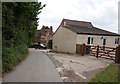
3
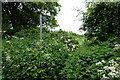
Lane up Tirley Hill
Looking north-west at the base of the hill.
Image: © Jonathan Billinger
Taken: 18 Sep 2009
0.09 miles
4
Footpath to Hasfield
Looking east into the pasture in Image
Image: © Jonathan Billinger
Taken: 18 Sep 2009
0.15 miles
5
Severn floodplain near Hasfield
Looking along the line of a footpath with Barrow Hill distinct in the distance.
Image: © Jonathan Billinger
Taken: 18 Sep 2009
0.16 miles
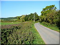
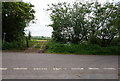
7

Road to Tirley Hill, Gloucestershire
Image: © Ruth Sharville
Taken: 15 Jul 2012
0.17 miles
9
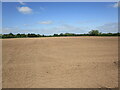
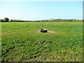
Prepared field near The Folly
Flat land close to the River Severn.
Image: © Jonathan Thacker
Taken: 30 May 2023
0.19 miles
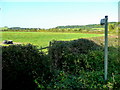
10

Gated entrance to field, Tirley, Gloucestershire
Image: © Ruth Sharville
Taken: 15 Jul 2012
0.19 miles