IMAGES TAKEN NEAR TO
Villard Close, GL19 4ER
Introduction
This page details the photographs taken nearby to Villard Close, GL19 4ER by members of the Geograph project.
The Geograph project started in 2005 with the aim of publishing, organising and preserving representative images for every square kilometre of Great Britain, Ireland and the Isle of Man.

There are currently over 7.5m images from over14,400 individuals and you can help contribute to the project by visiting https://www.geograph.org.uk
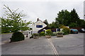
Image Map
Images are licensed for reuse under creativecommons.org/licenses/by-sa/2.0
Notes
- Clicking on the map will re-center to the selected point.
- The higher the marker number, the further away the image location is from the centre of the postcode.
Image Listing (41 Images Found)
Images are licensed for reuse under creativecommons.org/licenses/by-sa/2.0
Image
Details
Distance
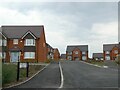
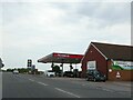
2
New housing development, Coombe Hill
Off the A38.
Image: © JThomas
Taken: 10 Aug 2021
0.03 miles
3
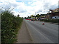
Roadworks on the A38, Coombe Hill
Towards Gloucester.
Image: © JThomas
Taken: 10 Aug 2021
0.04 miles

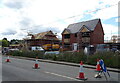
7
The Swan at Coombe Hill
http://www.geograph.org.uk/photo/4975688
Image: © Ian S
Taken: 26 May 2016
0.06 miles
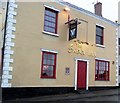
8
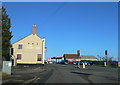
The Swan Inn, Coombe Hill
At the junction of the A38 and the A4019
Image: © Eirian Evans
Taken: 8 Jan 2011
0.06 miles
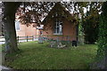
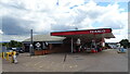
10
The Swan Inn, Coombe Hill, Gloucestershire
Image: © nick macneill
Taken: 11 Oct 2012
0.07 miles