IMAGES TAKEN NEAR TO
Cursey Lane, GLOUCESTER, GL19 4EP
Introduction
This page details the photographs taken nearby to Cursey Lane, GL19 4EP by members of the Geograph project.
The Geograph project started in 2005 with the aim of publishing, organising and preserving representative images for every square kilometre of Great Britain, Ireland and the Isle of Man.

There are currently over 7.5m images from over14,400 individuals and you can help contribute to the project by visiting https://www.geograph.org.uk
Image Map
Images are licensed for reuse under creativecommons.org/licenses/by-sa/2.0
Notes
- Clicking on the map will re-center to the selected point.
- The higher the marker number, the further away the image location is from the centre of the postcode.
Image Listing (4 Images Found)
Images are licensed for reuse under creativecommons.org/licenses/by-sa/2.0
Image
Details
Distance
1
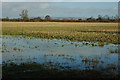
Arable land beside Cursey Lane
A waterlogged arable field to the north of Cyrsey Lane. Bredon Hill is on the horizon.
Image: © Philip Halling
Taken: 6 Dec 2009
0.06 miles
2
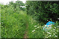
Flytipping near Cursey Lane
There are several deposits by the side of the bridleway, including a lot of broken glass.
Image: © Bill Boaden
Taken: 4 Jun 2018
0.18 miles
3
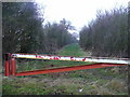
Bridleway to Tredington Park
Great lengths have been gone through to ensure that the green lane is reserved for non-wheeled traffic.
View north from Cursey Lane.
Image: © Jonathan Billinger
Taken: 14 Jan 2009
0.20 miles
4
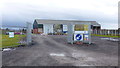
New agricultural business on Cursey Lane
Western Arable are a grain marketing business.
Image: © Jonathan Billinger
Taken: 12 Dec 2014
0.24 miles