IMAGES TAKEN NEAR TO
Chester Close, GLOUCESTER, GL19 4EA
Introduction
This page details the photographs taken nearby to Chester Close, GL19 4EA by members of the Geograph project.
The Geograph project started in 2005 with the aim of publishing, organising and preserving representative images for every square kilometre of Great Britain, Ireland and the Isle of Man.

There are currently over 7.5m images from over14,400 individuals and you can help contribute to the project by visiting https://www.geograph.org.uk
Image Map
Images are licensed for reuse under creativecommons.org/licenses/by-sa/2.0
Notes
- Clicking on the map will re-center to the selected point.
- The higher the marker number, the further away the image location is from the centre of the postcode.
Image Listing (42 Images Found)
Images are licensed for reuse under creativecommons.org/licenses/by-sa/2.0
Image
Details
Distance
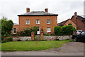
1
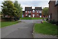
Modern houses in Apperley
Modern houses built in the late 1980s in the village of Apperley.
Image: © Philip Halling
Taken: 13 Sep 2015
0.00 miles
3
Gabb Lane
Leads to the River Severn and the Coalhouse Inn.
Image: © Pauline E
Taken: 20 Jul 2009
0.06 miles
4
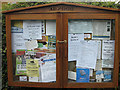
Notices, Apperley
Board erected in millennium year.
Image: © Pauline E
Taken: 20 Jul 2009
0.11 miles
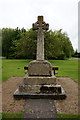
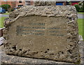
6
War Memorial, Apperley
Names from the 1st World War.
Image: © Ian S
Taken: 26 May 2016
0.15 miles
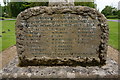
8
War Memorial, Apperley
Names from the 2nd World War.
Image: © Ian S
Taken: 26 May 2016
0.16 miles
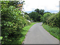
9
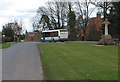
Rural bus service
Passing through Apperley, by the village green.
Image: © Pauline E
Taken: 7 Mar 2008
0.16 miles
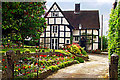
10
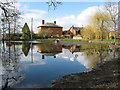
Green Farm, Apperley
Viewed across the village pond. A pretty village with an immaculate village green.
Image: © Pauline E
Taken: 7 Mar 2008
0.17 miles