IMAGES TAKEN NEAR TO
Straight Lane, GLOUCESTER, GL19 3RN
Introduction
This page details the photographs taken nearby to Straight Lane, GL19 3RN by members of the Geograph project.
The Geograph project started in 2005 with the aim of publishing, organising and preserving representative images for every square kilometre of Great Britain, Ireland and the Isle of Man.

There are currently over 7.5m images from over14,400 individuals and you can help contribute to the project by visiting https://www.geograph.org.uk
Image Map
Images are licensed for reuse under creativecommons.org/licenses/by-sa/2.0
Notes
- Clicking on the map will re-center to the selected point.
- The higher the marker number, the further away the image location is from the centre of the postcode.
Image Listing (9 Images Found)
Images are licensed for reuse under creativecommons.org/licenses/by-sa/2.0
Image
Details
Distance
1
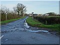
Country road at Staunton
Country road at Staunton with Lawn Farm on the right.
Image: © Philip Halling
Taken: 5 Dec 2020
0.08 miles
3
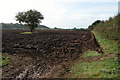
Corse Wood Hill
Corse Wood Hill viewed from a ploughed field beside the B4213.
Image: © Philip Halling
Taken: 9 Oct 2005
0.10 miles
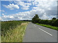
4
B4213 towards Staunton
Looking west on a drizzly October morning.
Image: © Jonathan Billinger
Taken: 15 Oct 2009
0.14 miles
5
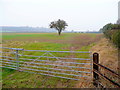
Site of a well
According to OS mapping the isolated hawthorn tree marks the position of a well south of the B4213 at Corse.
In the distance is Corse Wood Hill.
Image: © Jonathan Billinger
Taken: 15 Oct 2009
0.20 miles
6
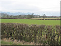
Flat farmland east of Staunton
With the Malvern Hills in the distance.
Image: © Pauline E
Taken: 21 Feb 2008
0.20 miles
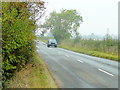
7
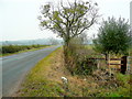
Edge of the B4213
Looking east towards Tirley.
Image: © Jonathan Billinger
Taken: 15 Oct 2009
0.21 miles
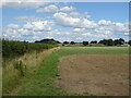
9
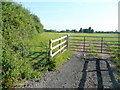
Pasture near Lawn Farm
Looking north towards Pillows Green.
The public footpath uses the pedestrian gate to the left.
Image: © Jonathan Billinger
Taken: 28 Jun 2010
0.23 miles