IMAGES TAKEN NEAR TO
Worcester Road, GLOUCESTER, GL19 3RL
Introduction
This page details the photographs taken nearby to Worcester Road, GL19 3RL by members of the Geograph project.
The Geograph project started in 2005 with the aim of publishing, organising and preserving representative images for every square kilometre of Great Britain, Ireland and the Isle of Man.

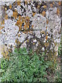
There are currently over 7.5m images from over14,400 individuals and you can help contribute to the project by visiting https://www.geograph.org.uk
Image Map
Images are licensed for reuse under creativecommons.org/licenses/by-sa/2.0
Notes
- Clicking on the map will re-center to the selected point.
- The higher the marker number, the further away the image location is from the centre of the postcode.
Image Listing (21 Images Found)
Images are licensed for reuse under creativecommons.org/licenses/by-sa/2.0
Image
Details
Distance
2
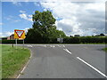
Junction of the B4213 with the B4211, Corse
Image: © JThomas
Taken: 10 Aug 2021
0.04 miles
3
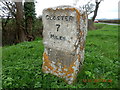
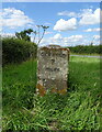
Old Milestone by the B4211, Corse
Carved stone post by the B4211, in parish of CORSE (FOREST OF DEAN District), Worcester Road; junction with Straight Lane (B4213), on wide grass verge just South of Walker's Farm, on South-West side of road. Maisemore marker, erected by the Maisemore (District of Hereford & Gloucester) Turnpike Trust in the 19th century.
Inscription reads:-
: GLOSTER / 7 / MILES : : (UPTON upon SEVERN / 9 / MILES) :
Grade II Listed. List Entry Number: 1303330
https://historicengland.org.uk/listing/the-list/list-entry/1303330
Milestone Society National ID: GL_GLUP07.
Image: © Milestone Society
Taken: 18 Mar 2017
0.05 miles
4
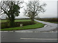
Corse, milestone
Milestone at the junction of B4211 and B4213, just South of Walker's Farm; bearing the legend "GLOSTER / 7 / MILES".
Image: © Mike Faherty
Taken: 13 Nov 2009
0.05 miles
5
Ordnance Survey Cut Mark
This OS cut mark can be found on the Gloucester 7 Milestone. It marks a point 32.982m above mean sea level. http://www.geograph.org.uk/photo/4374884
Image: © Adrian Dust
Taken: 7 Mar 2015
0.05 miles
6
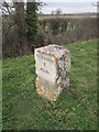
Milestone - Gloucester 7
There is an Ordnance Survey cut mark on the east face. http://www.geograph.org.uk/photo/4374881
Image: © Adrian Dust
Taken: 7 Mar 2015
0.05 miles
7
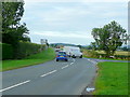
B Road junction
The B4211 ahead towards Gloucester and right towards Staunton.
Image: © Jonathan Billinger
Taken: 16 Sep 2010
0.05 miles
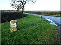
9
Old Milestone on the B4211
Inscription reads - "GLOSTER 7 MILES"
Image: © JThomas
Taken: 10 Aug 2021
0.06 miles
10
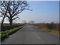
Milestone at Corse
A milestone on the junction of the B4213 with the B4211 at Corse.
Image: © Philip Halling
Taken: 5 Dec 2020
0.06 miles