IMAGES TAKEN NEAR TO
Gloucester Road, GLOUCESTER, GL19 3RB
Introduction
This page details the photographs taken nearby to Gloucester Road, GL19 3RB by members of the Geograph project.
The Geograph project started in 2005 with the aim of publishing, organising and preserving representative images for every square kilometre of Great Britain, Ireland and the Isle of Man.

There are currently over 7.5m images from over14,400 individuals and you can help contribute to the project by visiting https://www.geograph.org.uk
Image Map
Images are licensed for reuse under creativecommons.org/licenses/by-sa/2.0
Notes
- Clicking on the map will re-center to the selected point.
- The higher the marker number, the further away the image location is from the centre of the postcode.
Image Listing (16 Images Found)
Images are licensed for reuse under creativecommons.org/licenses/by-sa/2.0
Image
Details
Distance
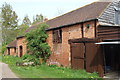
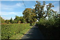
2
Footpath junction at Snig's End 2
The footpath crossroads of the Whitmore Way (dedicated to John Whitmore 1944-1987) and the Three Choirs Way LDF to the south-east of Staunton.
Looking north.
Image: © Jonathan Billinger
Taken: 1 Jul 2010
0.15 miles
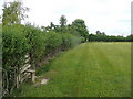
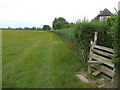
3
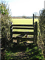
Stile in Corse
The map tells me I can choose from three routes, the waymarker sends me right.
Image: © Pauline E
Taken: 6 Feb 2008
0.17 miles
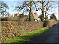
4
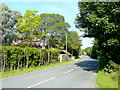
B4213 near Staunton
Looking west towards the combined village of Corse and Staunton.
Image: © Jonathan Billinger
Taken: 28 Jun 2010
0.19 miles
5
Footpath junction at Snig's End 1
The footpath crossroads of the Whitmore Way (dedicated to John Whitmore 1944-1987) and the Three Choirs Way LDF to the south-east of Staunton.
Looking south.
Image: © Jonathan Billinger
Taken: 1 Jul 2010
0.19 miles
7
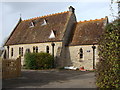
The Old School, Corse
Though rather more reminiscent of a church or chapel, I am assured by a local resident that this was indeed once the school.
Image: © Ruth Sharville
Taken: 7 Nov 2009
0.19 miles
8
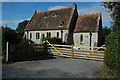
Converted school in Snig's End
A converted school building at Snig's End in Corse. Formerly it was Corse and Staunton C of E School. Earlier it was Corse C of E School, before Staunton C of E School was merged with it.
Image: © Philip Halling
Taken: 24 Sep 2009
0.21 miles
9
Snig's End, Corse
No through road at Snig's End, Corse. Down this road are a number of Chartist dwellings each with its own small plot of land.
Image: © Philip Halling
Taken: 24 Sep 2009
0.21 miles
10
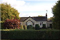
Chartist bungalow on the A417 at Snig's End, Gloucestershire
Image: © Roger Davies
Taken: 10 Oct 2009
0.22 miles