IMAGES TAKEN NEAR TO
Old Pike, GLOUCESTER, GL19 3QL
Introduction
This page details the photographs taken nearby to Old Pike, GL19 3QL by members of the Geograph project.
The Geograph project started in 2005 with the aim of publishing, organising and preserving representative images for every square kilometre of Great Britain, Ireland and the Isle of Man.

There are currently over 7.5m images from over14,400 individuals and you can help contribute to the project by visiting https://www.geograph.org.uk
Image Map
Images are licensed for reuse under creativecommons.org/licenses/by-sa/2.0
Notes
- Clicking on the map will re-center to the selected point.
- The higher the marker number, the further away the image location is from the centre of the postcode.
Image Listing (7 Images Found)
Images are licensed for reuse under creativecommons.org/licenses/by-sa/2.0
Image
Details
Distance
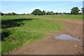
1
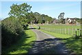
Track approaching cottages
Track and footpath approaching cottages near Staunton. The footpath passes in front of the cottage following the fencing to the right.
Image: © Philip Halling
Taken: 15 Oct 2023
0.06 miles
3
Barn at Sacksfield Farm
A large new barn at Sacksfield Farm near Staunton.
Image: © Philip Halling
Taken: 15 Oct 2023
0.20 miles
4
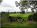
View across a gate
Lovely countryside west of Hethelpit Cross.
Image: © Pauline E
Taken: 23 Aug 2008
0.20 miles
5
Field at Sladbrook
Field at Sladbrook near Staunton.
Image: © Philip Halling
Taken: 15 Oct 2023
0.22 miles
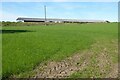
6
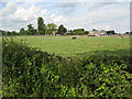
Sacksfield Farm near Staunton
Sacksfield Farm viewed from the south-west.
Image: © Philip Halling
Taken: 13 Jul 2008
0.23 miles
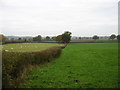
7
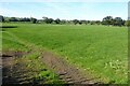
Farmland at Staunton
Farmland to the west of Staunton.
Image: © Philip Halling
Taken: 15 Oct 2023
0.24 miles