IMAGES TAKEN NEAR TO
Ledbury Road Crescent, GLOUCESTER, GL19 3QB
Introduction
This page details the photographs taken nearby to Ledbury Road Crescent, GL19 3QB by members of the Geograph project.
The Geograph project started in 2005 with the aim of publishing, organising and preserving representative images for every square kilometre of Great Britain, Ireland and the Isle of Man.

There are currently over 7.5m images from over14,400 individuals and you can help contribute to the project by visiting https://www.geograph.org.uk
Image Map
Images are licensed for reuse under creativecommons.org/licenses/by-sa/2.0
Notes
- Clicking on the map will re-center to the selected point.
- The higher the marker number, the further away the image location is from the centre of the postcode.
Image Listing (25 Images Found)
Images are licensed for reuse under creativecommons.org/licenses/by-sa/2.0
Image
Details
Distance
1

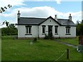
Former Chartist Land Company cottages at Snigs End, Staunton
The Chartist estate at Snigs End extended to over 268 acres around the village of Staunton and was built between 1847 and 1851. The 81 plot development included cottages to a common design (as seen here), a schoolhouse and a network of roads and pathways. The original settlers won their cottage with a 3 or 4 acre plot through a lottery and were provided with supplies of manure, firewood and seed. In 1848, the third National Chartist petition was taken to Parliament on a cart made at Snigs End and pulled by Snigs End horses. The "colonies" were declared illegal by a House of Commons Select Committee in 1851 and the properties sold off. Their founding light, Feargus O'Connor, died shortly after declared a lunatic.
Image: © Roger Davies
Taken: 10 Oct 2009
0.02 miles
2

A Chartist goat
This lucky goat has an entire Chartist plot to himself (herself?) at Ledbury Road Crescent.
Image: © Philip Pankhurst
Taken: 13 Apr 2014
0.03 miles
3
Chartist Bungalow, Ledbury Road Crescent, Staunton
Image: © Paul Shreeve
Taken: 13 Jul 2009
0.05 miles
4

Chartist Bungalow, Ledbury Road Crescent, Staunton
Image: © Paul Shreeve
Taken: 13 Jul 2009
0.05 miles
5
Chartist cottage, Ledbury Road Crescent
The dignified design and the very large self-sustaining plots on which the Chartist houses were built make them very desirable today. Only the roaring traffic on the nearby A417 tarnishes the idyll.
Image: © Philip Pankhurst
Taken: 13 Apr 2014
0.06 miles
6
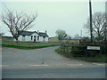
Ledbury Road Crescent
Not quite in the same league as the Georgian versions in Bath, and most of the houses on the loop of road to the south of the A417 at Staunton are these detached pre-WW2 bungalows.
Image: © Jonathan Billinger
Taken: 15 Mar 2011
0.09 miles
7
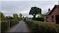
Ledbury Road Crescent
A lane parallel with the A417 with a series of Chartists' houses to the right.
Image: © Jonathan Billinger
Taken: 31 Oct 2012
0.09 miles
8

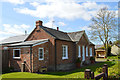
Former National School, Staunton
Dating from 1861-2 by G.R. Clarke. Seen across a Chartist plot from Ledbury Road Crescent.
Image: © Philip Pankhurst
Taken: 13 Apr 2014
0.09 miles

