IMAGES TAKEN NEAR TO
Pendock, GLOUCESTER, GL19 3PJ
Introduction
This page details the photographs taken nearby to GL19 3PJ by members of the Geograph project.
The Geograph project started in 2005 with the aim of publishing, organising and preserving representative images for every square kilometre of Great Britain, Ireland and the Isle of Man.

There are currently over 7.5m images from over14,400 individuals and you can help contribute to the project by visiting https://www.geograph.org.uk
Image Map
Images are licensed for reuse under creativecommons.org/licenses/by-sa/2.0
Notes
- Clicking on the map will re-center to the selected point.
- The higher the marker number, the further away the image location is from the centre of the postcode.
Image Listing (18 Images Found)
Images are licensed for reuse under creativecommons.org/licenses/by-sa/2.0
Image
Details
Distance
1
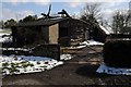
A tumbledown barn
A barn in a sorry state on a smallholder near Portway, Pendock.
Image: © Philip Halling
Taken: 19 Mar 2018
0.01 miles
2
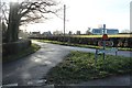
Wyndbrook Lane
At the junction with Cook's Lane.
Image: © Bob Embleton
Taken: 24 Jan 2015
0.06 miles
3
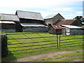
Farm buildings at Wyndbrook
A collection of various farm sheds around a yard, the tidy lawn-like grass suggests the buildings have not had livestock around for some time.
Image: © Philip Halling
Taken: 13 Jul 2008
0.07 miles
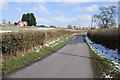
4
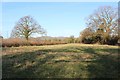
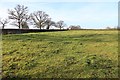
Meadow near Berrends
The narrow strip between the lane to Berrends and the Wynd Brook has just come up for sale by auction. Punters are warned that it floods.
Image: © Bob Embleton
Taken: 24 Jan 2015
0.07 miles
5
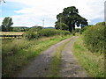
Entrance to Berrends
The southern end of the Malvern Hills can be seen in the background.
Image: © Philip Halling
Taken: 13 Jul 2008
0.07 miles
6
Cook's Lane
Cook's Lane approaching the B4208 at Portway to the north of Pendock.
Image: © Philip Halling
Taken: 19 Mar 2018
0.07 miles
7
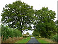
Wyndbrook Lane 2
Still-green oaks in this mild October 2008.
Image: © Jonathan Billinger
Taken: 20 Oct 2008
0.08 miles
8
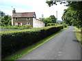
Cottage at Wyndbrook
This traditional cottage with its vegetable garden in front is on the side of a lane just within the county of Gloucestershire and just north of the M50.
Image: © Philip Halling
Taken: 13 Jul 2008
0.08 miles
9
Old road visible in a field
A slight holloway showing an old routeway parallel to and probably pre-dating Cook's Lane.
Image: © Bob Embleton
Taken: 24 Jan 2015
0.09 miles
10
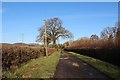
The track to Berrends Farm
The field on the right of the hedge is up for sale - by auction.
Image: © Bob Embleton
Taken: 24 Jan 2015
0.11 miles