IMAGES TAKEN NEAR TO
Staunton, GLOUCESTER, GL19 3PD
Introduction
This page details the photographs taken nearby to GL19 3PD by members of the Geograph project.
The Geograph project started in 2005 with the aim of publishing, organising and preserving representative images for every square kilometre of Great Britain, Ireland and the Isle of Man.

There are currently over 7.5m images from over14,400 individuals and you can help contribute to the project by visiting https://www.geograph.org.uk
Image Map
Images are licensed for reuse under creativecommons.org/licenses/by-sa/2.0
Notes
- Clicking on the map will re-center to the selected point.
- The higher the marker number, the further away the image location is from the centre of the postcode.
Image Listing (11 Images Found)
Images are licensed for reuse under creativecommons.org/licenses/by-sa/2.0
Image
Details
Distance
1
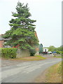
Dobshill Farm
The farm is north-west of Gadfield Elm in Worcestershire.
Image: © Jonathan Billinger
Taken: 10 Aug 2010
0.02 miles
2
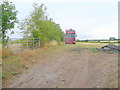
Parked up
A truck in a field by the footpath from Dobshill to Pendock.
Image: © Jonathan Billinger
Taken: 10 Aug 2010
0.04 miles
3

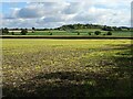
Footpath through stubble
Heading east from Dobshill in the general direction of Gadbury Bank.
Image: © Jonathan Billinger
Taken: 10 Aug 2010
0.14 miles
4
View to Gadbury Bank
View across farmland to New Barn Cottages and Gadbury Bank, a now wooded hill fort viewed from opposite Dobshill Farm. This is the view from the opposite direction Image
Image: © Philip Halling
Taken: 13 Oct 2020
0.16 miles
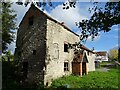
5
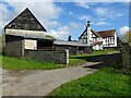
Farm Mill
The timber-framed farmhouse at Farm Mill, the barn on the left is Grade II listed, see: https://historicengland.org.uk/listing/the-list/list-entry/1078493
Image: © Philip Halling
Taken: 13 Oct 2020
0.19 miles
6
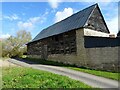
Barn at Farm Mill
Traditional barn at Farm Mill at Lowbands.
The barn is grade II listed, see: https://historicengland.org.uk/listing/the-list/list-entry/1078493
Image: © Philip Halling
Taken: 13 Oct 2020
0.20 miles
7
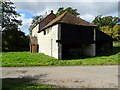
Mill at Farm Mill
The former Mill opposite Farm Mill in Lowbands. The mill is Grade II listed, see: https://historicengland.org.uk/listing/the-list/list-entry/1156622
Image: © Philip Halling
Taken: 13 Oct 2020
0.21 miles
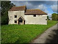
8
Mill at Farm Mill
The former Mill opposite Farm Mill in Lowbands, the farmhouse of Farm Mill can be seen in the background. The mill is Grade II listed, see: https://historicengland.org.uk/listing/the-list/list-entry/1156622
Image: © Philip Halling
Taken: 13 Oct 2020
0.21 miles
9
Mill at Farm Mill
The former Mill opposite Farm Mill in Lowbands. The mill is Grade II listed, see: https://historicengland.org.uk/listing/the-list/list-entry/1156622
Image: © Philip Halling
Taken: 13 Oct 2020
0.21 miles
10
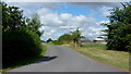
Lane to Pendock
Looking north from by Farm Mill.
Image: © Jonathan Billinger
Taken: 6 Aug 2015
0.21 miles