IMAGES TAKEN NEAR TO
Malvern Road, GLOUCESTER, GL19 3NZ
Introduction
This page details the photographs taken nearby to Malvern Road, GL19 3NZ by members of the Geograph project.
The Geograph project started in 2005 with the aim of publishing, organising and preserving representative images for every square kilometre of Great Britain, Ireland and the Isle of Man.

There are currently over 7.5m images from over14,400 individuals and you can help contribute to the project by visiting https://www.geograph.org.uk
Image Map
Images are licensed for reuse under creativecommons.org/licenses/by-sa/2.0
Notes
- Clicking on the map will re-center to the selected point.
- The higher the marker number, the further away the image location is from the centre of the postcode.
Image Listing (9 Images Found)
Images are licensed for reuse under creativecommons.org/licenses/by-sa/2.0
Image
Details
Distance
1
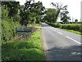
Is this really 'the end of civilisation?'
The Worcestershire/Gloucestershire county boundary on the B4208.
Image: © Philip Halling
Taken: 13 Jul 2008
0.05 miles
2
The end of civilisation
Some say one can reach Staunton if one dares to pass this point. Looking south down the B4208.
Image: © Bob Embleton
Taken: 15 Jul 2005
0.06 miles
3
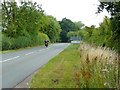
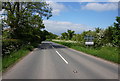
Entering Worcestershire
The Saturday morning motorcyclist is heading north towards Pendock.
Note the change of road surface at the county boundary.
Image: © Jonathan Billinger
Taken: 7 Aug 2010
0.07 miles
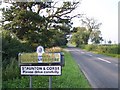
4
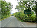
Staunton and Corse
Approaching the amalgamated village from the north, this sign is on the reverse of the Worcestershire county sign.
See; Image
Also the signs have been changed since Image and Image
Image: © Jonathan Billinger
Taken: 7 Aug 2010
0.07 miles
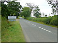
5
B4208 looking north
Alongside the entrance to Greenfields Funeral Services; see http://www.greenfieldswoodlandburials.co.uk/
Image: © Jonathan Billinger
Taken: 7 Aug 2010
0.10 miles
6
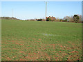
County border, Gloucestershire meets Worcestershire
The house is in Worcestershire, most of the field is in Gloucestershire.
Image: © Pauline E
Taken: 6 Feb 2008
0.13 miles
8
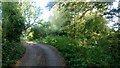
Dead end lane by Red House
The track ahead towards Eldersfield is mostly obscured by scrubby vegetation.
Image: © Jonathan Billinger
Taken: 20 Oct 2015
0.15 miles
9

Road junction north of Staunton
From the footpath to Eldersfield.
Image: © Pauline E
Taken: 6 Feb 2008
0.20 miles