IMAGES TAKEN NEAR TO
The Heath, GLOUCESTER, GL19 3ND
Introduction
This page details the photographs taken nearby to The Heath, GL19 3ND by members of the Geograph project.
The Geograph project started in 2005 with the aim of publishing, organising and preserving representative images for every square kilometre of Great Britain, Ireland and the Isle of Man.

There are currently over 7.5m images from over14,400 individuals and you can help contribute to the project by visiting https://www.geograph.org.uk
Image Map
Images are licensed for reuse under creativecommons.org/licenses/by-sa/2.0
Notes
- Clicking on the map will re-center to the selected point.
- The higher the marker number, the further away the image location is from the centre of the postcode.
Image Listing (16 Images Found)
Images are licensed for reuse under creativecommons.org/licenses/by-sa/2.0
Image
Details
Distance
2
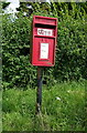
Elizabeth II postbox on the A417, The Heath
Postbox No. GL19 35.
Image: © JThomas
Taken: 10 Aug 2021
0.03 miles
3
Hillside east of the A417
Viewed from the minor road to Lowbands.
Image: © Pauline E
Taken: 29 Sep 2008
0.08 miles
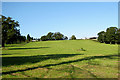
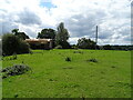
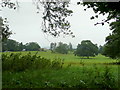
4
Down House Parkland
looking north towards Hartledgehill Farm
Image: © Bob Embleton
Taken: 15 Jul 2005
0.12 miles
5
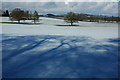
Snow covered farmland, near Redmarley
Snow covered farmland to the north of Down House Land near Redmarley. The Malvern Hills are in the distance.
Image: © Philip Halling
Taken: 21 Feb 2010
0.14 miles
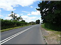
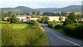
7
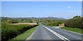
A417 leaving the high ground of Redmarley d'Abitot
The main road drops down a gentle slope, giving views towards the Malvern Hills
Image: © David Smith
Taken: 22 Apr 2015
0.16 miles
8
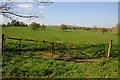
Farmland to the south of Redmarley D'abitot
Farmland to the south of Redmarley D'abitot, the southern end of the Malvern Hills can be seen in the distance.
Image: © Philip Halling
Taken: 18 Apr 2014
0.16 miles
9
A417; early morning
Looking north on a fine early autumn day towards the southern end of the Malvern Hills in the blue distance.
Image: © Jonathan Billinger
Taken: 18 Sep 2012
0.17 miles
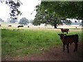
10
Down House parkland
Title borrowed from the first geograph for this square - Image, taken almost exactly five years before this scene.
Image: © Jonathan Billinger
Taken: 20 Jul 2010
0.18 miles