IMAGES TAKEN NEAR TO
Redmarley, GLOUCESTER, GL19 3LR
Introduction
This page details the photographs taken nearby to GL19 3LR by members of the Geograph project.
The Geograph project started in 2005 with the aim of publishing, organising and preserving representative images for every square kilometre of Great Britain, Ireland and the Isle of Man.

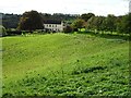
There are currently over 7.5m images from over14,400 individuals and you can help contribute to the project by visiting https://www.geograph.org.uk
Image Map
Images are licensed for reuse under creativecommons.org/licenses/by-sa/2.0
Notes
- Clicking on the map will re-center to the selected point.
- The higher the marker number, the further away the image location is from the centre of the postcode.
Image Listing (19 Images Found)
Images are licensed for reuse under creativecommons.org/licenses/by-sa/2.0
Image
Details
Distance
1

Murrell's End Farm
Murrell's End Farm pictured on a frosty foggy January morning.
Image: © Philip Halling
Taken: 13 Jan 2022
0.02 miles
2
Murrell's End Farm
Murrell's End Farm viewed from Durbridge Road.
Image: © Philip Halling
Taken: 6 Oct 2020
0.04 miles
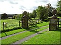
3
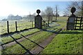
Gate piers at the entrance to Murrell's End Farm
Gate piers at the entrance to Murrell's End Farm on a frosty and foggy January morning.
Image: © Philip Halling
Taken: 13 Jan 2022
0.11 miles
4
Entrance to Merrill's End Farm
The same view as the first picture uploaded into this square in 2005 Image, the scene little changed in fifteen years other than the loss of a couple of trees in front of the house on the left.
Image: © Philip Halling
Taken: 6 Oct 2020
0.11 miles
5

Highfield Farm
Highfield Farm above the Leadon valley, viewed from the Poet's Path No.1.
Image: © Philip Halling
Taken: 13 Jan 2022
0.12 miles
6
Poets' Path No.1 to Ketford
Drops quickly down to the River Leadon.
Image: © Jonathan Thacker
Taken: 16 Sep 2015
0.14 miles
7
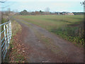
Farm track off Durbridge Road
Looking north from the entrance of a track which leads to some barns. Cobhill Rough beyond and the tops of the Malvern Hills in the distance.
Image: © Trevor Rickard
Taken: 19 Nov 2008
0.15 miles
8
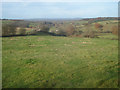
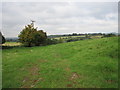
Pasture north of Durbridge Road
Looking north-west with Cutmill Farm in the valley below. Marcle Hill on the horizon.
Image: © Trevor Rickard
Taken: 19 Nov 2008
0.16 miles
9
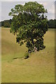
Tree on a ridge
Tree on a ridge in a field viewed from one of the Poets Path emanating from the nearby village of Dymock.
Image: © Philip Halling
Taken: 14 Jul 2011
0.17 miles
10
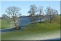
Trees on a bank
Trees on a bank or ridge above the Leadon valley.
Image: © Philip Halling
Taken: 13 Jan 2022
0.17 miles