IMAGES TAKEN NEAR TO
Ledbury Road, GLOUCESTER, GL19 3JY
Introduction
This page details the photographs taken nearby to Ledbury Road, GL19 3JY by members of the Geograph project.
The Geograph project started in 2005 with the aim of publishing, organising and preserving representative images for every square kilometre of Great Britain, Ireland and the Isle of Man.

There are currently over 7.5m images from over14,400 individuals and you can help contribute to the project by visiting https://www.geograph.org.uk
Image Map
Images are licensed for reuse under creativecommons.org/licenses/by-sa/2.0
Notes
- Clicking on the map will re-center to the selected point.
- The higher the marker number, the further away the image location is from the centre of the postcode.
Image Listing (16 Images Found)
Images are licensed for reuse under creativecommons.org/licenses/by-sa/2.0
Image
Details
Distance
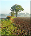
1
Autumnal dawn
The line of the public path from Pound House to Parkgate.
Image: © Jonathan Billinger
Taken: 26 Oct 2011
0.04 miles
2
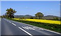
A field of rape north of Redmarley
In the broad valley of Glynch Brook, with the Malvern Hills on the horizon
Image: © David Smith
Taken: 22 Apr 2015
0.10 miles
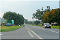
3
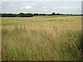
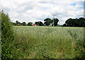
Fields of wheat near Redmarley D'Abitot
View across wheat fields to the east of the A417 to the north of Redmarley D'Abitot.
Image: © Philip Halling
Taken: 13 Jul 2008
0.11 miles

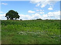
7
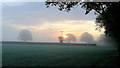
Autumn edge
The morning mist in the shallow Glynch valley is burning off on this fine September day.
Image: © Jonathan Billinger
Taken: 28 Sep 2011
0.15 miles
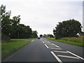
9
Romany caravan by the A417
This traveller has been parked up for a few days on the wide verge of the Gloucester Road at Playley Green.
Image: © Jonathan Billinger
Taken: 11 Oct 2010
0.16 miles
10
Wheat field near Playley Green
On the road to Pendock.
Image: © Pauline E
Taken: 17 Jun 2008
0.16 miles