IMAGES TAKEN NEAR TO
Orchard Way, GLOUCESTER, GL19 3HP
Introduction
This page details the photographs taken nearby to Orchard Way, GL19 3HP by members of the Geograph project.
The Geograph project started in 2005 with the aim of publishing, organising and preserving representative images for every square kilometre of Great Britain, Ireland and the Isle of Man.

There are currently over 7.5m images from over14,400 individuals and you can help contribute to the project by visiting https://www.geograph.org.uk
Image Map
Images are licensed for reuse under creativecommons.org/licenses/by-sa/2.0
Notes
- Clicking on the map will re-center to the selected point.
- The higher the marker number, the further away the image location is from the centre of the postcode.
Image Listing (58 Images Found)
Images are licensed for reuse under creativecommons.org/licenses/by-sa/2.0
Image
Details
Distance
1
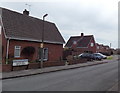
Westwick Road, Huntley
Viewed from the corner of Tibberton Lane. Westwick Road leads to Newton Close and Sunset Place.
Image: © Jaggery
Taken: 21 Apr 2013
0.06 miles
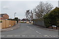
2
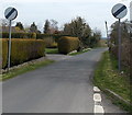
End of the 30mph zone through Huntley
A few metres beyond the Bramley Drive junction, the 30mph speed limit along Tibberton Lane increases to the National Speed Limit.
Image: © Jaggery
Taken: 21 Apr 2013
0.07 miles
3
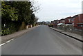
Tibberton Lane, Huntley
Viewed from the corner of Frog Lane looking towards Frogmore Road and Westwick Road.
Image: © Jaggery
Taken: 21 Apr 2013
0.09 miles
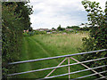
4
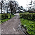
Northern entrance to Orchard Golf Course, Huntley
Viewed from Tibberton Lane. A stile on the left side of the gate gives access to a public footpath ahead.
Image: © Jaggery
Taken: 21 Apr 2013
0.09 miles
5
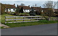
Tibberton Lane bungalows, Huntley
The bungalows are set back from the north side of the lane, with long (c35 metres) front gardens.
Image: © Jaggery
Taken: 21 Apr 2013
0.09 miles
6
Frogmore Road, Huntley
Viewed from Tibberton Lane.
Image: © Jaggery
Taken: 21 Apr 2013
0.10 miles
7
Allotments at Huntley
Situated on land that was once the common. This was enclosed in 1857.
Image: © Pauline E
Taken: 16 Aug 2007
0.12 miles
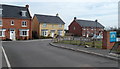
8
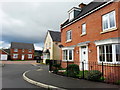
Modern housing in Huntley
Situated on the edge of a golf course.
Image: © Jonathan Billinger
Taken: 7 Apr 2014
0.12 miles
9
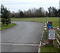
Golf access only, Huntley
This is the entrance to Orchard Golf Course from the A40 via The Fairways. http://www.geograph.org.uk/photo/3795776
Notices on the brick column state and restate the same message - private road, NOT a public footpath, golf course entry ONLY, NO public right of way, access not permitted, golf access only.
And Section 31 of the Highways Act 1980 is mentioned, for good measure...
Image: © Jaggery
Taken: 21 Apr 2013
0.13 miles
10
The Fairways, Huntley
Recently-built houses on the north side of the A40, near the SW corner of Orchard Golf Course.
Image: © Jaggery
Taken: 21 Apr 2013
0.13 miles