IMAGES TAKEN NEAR TO
Newent Lane, GLOUCESTER, GL19 3HG
Introduction
This page details the photographs taken nearby to Newent Lane, GL19 3HG by members of the Geograph project.
The Geograph project started in 2005 with the aim of publishing, organising and preserving representative images for every square kilometre of Great Britain, Ireland and the Isle of Man.

There are currently over 7.5m images from over14,400 individuals and you can help contribute to the project by visiting https://www.geograph.org.uk
Image Map
Images are licensed for reuse under creativecommons.org/licenses/by-sa/2.0
Notes
- Clicking on the map will re-center to the selected point.
- The higher the marker number, the further away the image location is from the centre of the postcode.
Image Listing (16 Images Found)
Images are licensed for reuse under creativecommons.org/licenses/by-sa/2.0
Image
Details
Distance
3
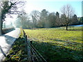
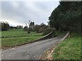
Winter sunshine
Parkland alongside the B4216 Newent Lane near Huntley.
Image: © Jonathan Billinger
Taken: 5 Dec 2010
0.08 miles
4
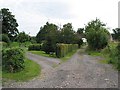
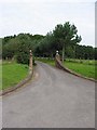
Farmhouse entrance near Huntley
Bear left for Northend Farmhouse.
Image: © Pauline E
Taken: 23 Aug 2007
0.10 miles
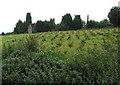
6
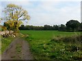
Track and footpath
Looking east from Northend farm towards Great Adam's Wood.
Image: © Jonathan Billinger
Taken: 18 Oct 2018
0.14 miles

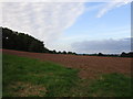
8
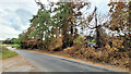
Evidence of a recent wildfire
Hot, dry conditions in the summer of 2022 have resulted in this roadside fire on Newent Lane.
Image: © Jonathan Billinger
Taken: 23 Aug 2022
0.16 miles
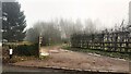
9
Grand entrance
Sweeping through a corner of Castle Hill Wood.
Image: © Pauline E
Taken: 23 Aug 2007
0.17 miles