IMAGES TAKEN NEAR TO
Redmarley, GLOUCESTER, GL19 3FE
Introduction
This page details the photographs taken nearby to GL19 3FE by members of the Geograph project.
The Geograph project started in 2005 with the aim of publishing, organising and preserving representative images for every square kilometre of Great Britain, Ireland and the Isle of Man.

There are currently over 7.5m images from over14,400 individuals and you can help contribute to the project by visiting https://www.geograph.org.uk
Image Map
Images are licensed for reuse under creativecommons.org/licenses/by-sa/2.0
Notes
- Clicking on the map will re-center to the selected point.
- The higher the marker number, the further away the image location is from the centre of the postcode.
Image Listing (26 Images Found)
Images are licensed for reuse under creativecommons.org/licenses/by-sa/2.0
Image
Details
Distance
1
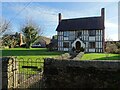
Timber-framed house on Drury Lane
A timber-framed former farmhouse on Drury Lane in Redmarley D'Abitot. The house dates from the early 17th century and is Grade II listed, see: https://historicengland.org.uk/listing/the-list/list-entry/1078488
Image: © Philip Halling
Taken: 1 Dec 2020
0.08 miles
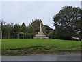
2
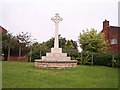
Redmarley D'Abitot War Memorial
At the northern end of the village. For more information on this village start at :-
http://www.genuki.org.uk/big/eng/GLS/RedmarleydAbitot/
Image: © Bob Embleton
Taken: 15 Jul 2005
0.08 miles
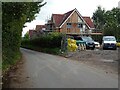
3
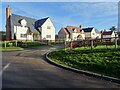
New houses in Redmarley D'Abitot
New houses off Drury Lane in Redmarley D'Abitot.
Image: © Philip Halling
Taken: 1 Dec 2020
0.09 miles
4
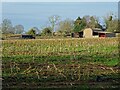
Dutch barn and lean-tos
A Dutch barn with lean-tos on both sides viewed across a field of stubble left from a harvested maize crop.
Image: © Philip Halling
Taken: 1 Dec 2020
0.11 miles
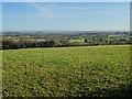
5
Pastoral scene near Redmarley D'Abitot 2
The opposite view to Image taken 24 hours later on a much cloudier day.
Image: © Jonathan Billinger
Taken: 17 Aug 2010
0.12 miles
6
House building in Redmarley D'Abitot
New houses being built on Bromsberrow Road in Redmarley D'Abitot.
Image: © Philip Halling
Taken: 6 Oct 2020
0.14 miles
7
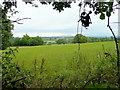
View of Gloucestershire countryside
Gloucestershire has three distinct geographical regions, the Forest of Dean in the west, the high ground of the Cotswold Hills in the east and the vale through which the River Severn flows in the centre. Here we have a view over the vale from Redmarley D'Abitot with the escarpment of the Cotswold Hills in the distance.
Image: © Philip Halling
Taken: 1 Dec 2020
0.14 miles
8
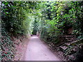
Drury Lane
Deeply cut into the red sandstone of the low hills on the Gloucester/Worcester border.
Image: © Jonathan Billinger
Taken: 17 Aug 2010
0.15 miles
10
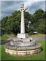
Redmarley D'Abitot War Memorial
The War Memorial in Redmarley D'Abitot stands a green by a crossroads.
Image: © Philip Halling
Taken: 13 Jul 2008
0.16 miles