IMAGES TAKEN NEAR TO
Sunset Place, GLOUCESTER, GL19 3ER
Introduction
This page details the photographs taken nearby to Sunset Place, GL19 3ER by members of the Geograph project.
The Geograph project started in 2005 with the aim of publishing, organising and preserving representative images for every square kilometre of Great Britain, Ireland and the Isle of Man.

There are currently over 7.5m images from over14,400 individuals and you can help contribute to the project by visiting https://www.geograph.org.uk
Image Map
Images are licensed for reuse under creativecommons.org/licenses/by-sa/2.0
Notes
- Clicking on the map will re-center to the selected point.
- The higher the marker number, the further away the image location is from the centre of the postcode.
Image Listing (68 Images Found)
Images are licensed for reuse under creativecommons.org/licenses/by-sa/2.0
Image
Details
Distance
1
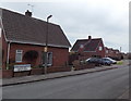
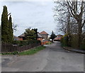
Westwick Road, Huntley
Viewed from the corner of Tibberton Lane. Westwick Road leads to Newton Close and Sunset Place.
Image: © Jaggery
Taken: 21 Apr 2013
0.05 miles
2
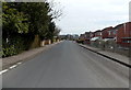
Tibberton Lane, Huntley
Viewed from the corner of Frog Lane looking towards Frogmore Road and Westwick Road.
Image: © Jaggery
Taken: 21 Apr 2013
0.05 miles
3
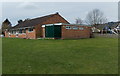
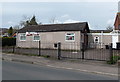
Huntley Village Hall
The hall is set back from North Road in Huntley, behind a children's play area.
The building has one meeting room and a medium sized hall with kitchen.
There are facilities for football teams, and a football pitch on the east side of the hall.
Image: © Jaggery
Taken: 21 Apr 2013
0.07 miles
4
Huntley Village Hall
Viewed across North Road. The building has one meeting room and a medium sized hall with kitchen. There are facilities for football teams, and a football pitch on the east side of the hall.
Image: © Jaggery
Taken: 21 Apr 2013
0.07 miles
5
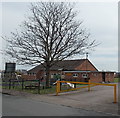
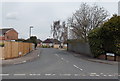
Scout Hall in Huntley
Viewed across North Road. The hall is used by the 1st Mayhill and Huntley Scout Group,
part of Forest of Dean District Scouts.
Image: © Jaggery
Taken: 21 Apr 2013
0.07 miles
6
Frog Lane, Huntley
Looking NE towards Frogmore Road and Byfords Road. This is not a through road for motor vehicles.
In the distance, three concrete posts block the way.
Image: © Jaggery
Taken: 21 Apr 2013
0.07 miles
7
Frogmore Road, Huntley
Viewed from Tibberton Lane.
Image: © Jaggery
Taken: 21 Apr 2013
0.09 miles
8
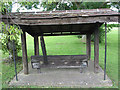
The Village Stocks, Huntley
Believed to be the only remaining stocks in the Forest of Dean.
Image: © Pauline E
Taken: 16 Aug 2007
0.09 miles
10
Allotments at Huntley
Situated on land that was once the common. This was enclosed in 1857.
Image: © Pauline E
Taken: 16 Aug 2007
0.10 miles