IMAGES TAKEN NEAR TO
Birdwood, GLOUCESTER, GL19 3EQ
Introduction
This page details the photographs taken nearby to GL19 3EQ by members of the Geograph project.
The Geograph project started in 2005 with the aim of publishing, organising and preserving representative images for every square kilometre of Great Britain, Ireland and the Isle of Man.

There are currently over 7.5m images from over14,400 individuals and you can help contribute to the project by visiting https://www.geograph.org.uk
Image Map
Images are licensed for reuse under creativecommons.org/licenses/by-sa/2.0
Notes
- Clicking on the map will re-center to the selected point.
- The higher the marker number, the further away the image location is from the centre of the postcode.
Image Listing (34 Images Found)
Images are licensed for reuse under creativecommons.org/licenses/by-sa/2.0
Image
Details
Distance
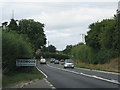
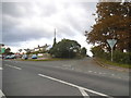
2
A40 at Birdwood
Looking east towards Gloucester.
Image: © Jonathan Billinger
Taken: 19 Jul 2011
0.10 miles
3
A40 at Chapel Lane, Birdwood
Looking east towards Gloucester.
Image: © Jonathan Billinger
Taken: 15 Jan 2010
0.11 miles
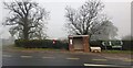
4
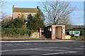
Bus Stop and Birdwood House
Bus Stop on the A40 and Birdwood House.
Image: © Philip Halling
Taken: 17 Dec 2011
0.11 miles
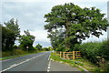
5

A40 on the way to Ross from Gloucester
Just outside Birdwood between Churcham and Huntley.
Image: © David Robinson
Taken: 30 Nov 2008
0.12 miles
6
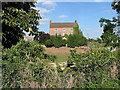
Birdwood House Farm
A substantial farmhouse with Gloucester Old Spots foraging in the yard.
Image: © Pauline E
Taken: 26 Aug 2007
0.12 miles
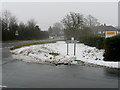
9
The A40 at the junction of Bulley Lane, Birdwood
Image: © David Howard
Taken: 17 Sep 2017
0.13 miles
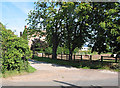
10
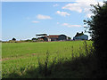
Farm buildings at Birdwood
From Bulley Lane
Image: © Pauline E
Taken: 26 Aug 2007
0.14 miles