IMAGES TAKEN NEAR TO
Woolridge Hill, GLOUCESTER, GL19 3DJ
Introduction
This page details the photographs taken nearby to Woolridge Hill, GL19 3DJ by members of the Geograph project.
The Geograph project started in 2005 with the aim of publishing, organising and preserving representative images for every square kilometre of Great Britain, Ireland and the Isle of Man.

There are currently over 7.5m images from over14,400 individuals and you can help contribute to the project by visiting https://www.geograph.org.uk
Image Map
Images are licensed for reuse under creativecommons.org/licenses/by-sa/2.0
Notes
- Clicking on the map will re-center to the selected point.
- The higher the marker number, the further away the image location is from the centre of the postcode.
Image Listing (8 Images Found)
Images are licensed for reuse under creativecommons.org/licenses/by-sa/2.0
Image
Details
Distance
1
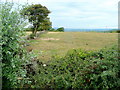
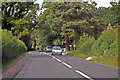
View west from Longridge
Looking west from Over Old Road with May Hill brooding darkly just to the right of the trees.
Image: © Jonathan Billinger
Taken: 20 Aug 2011
0.17 miles
2
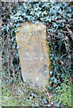
Old Milestone by the A417, Gloucester Road, Hartpury parish
Carved stone post by the A417, in parish of HARTPURY (FOREST OF DEAN District), Gloucester Road; Woolridge Farm, in hedge, on East side of road. Maisemore marker, erected by the Maisemore (District of Hereford & Gloucester) turnpike trust in the 19th century.
Inscription reads:-
GLOSTER
4
MILES
Grade II listed.
List Entry Number: 1078667 https://historicengland.org.uk/listing/the-list/list-entry/1078667
Milestone Society National ID: GL_GLLB04.
Image: © R Shackell
Taken: 14 Mar 2014
0.21 miles
3
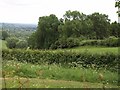
Edge of woodland below Woolridge
The unnamed wood is on the steep slopes dropping to the Severn east of Woolridge.
Image: © Derek Harper
Taken: 28 May 2009
0.21 miles
4
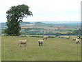
View across the Severn
Sandhurst Hill in the distance is approximately the same height as the camera position on Longridge where these sheep are grazing.
The Cotswold scarp is in the far distance.
Image: © Jonathan Billinger
Taken: 20 Aug 2011
0.22 miles
5
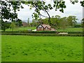
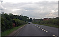
A417 towards Hartpury
On the right can be seen the roof of the old school, now The Marlowe Child & Family Services Education Unit.
Image: © J.Hannan-Briggs
Taken: 27 Jul 2014
0.22 miles
6
Tweenhills Cottage, Hartpury
My house!
Image: © Duncan Miller
Taken: 2 May 2005
0.22 miles
8
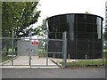
Water tank, Woolridge
Severn Trent Water.
Image: © Pauline E
Taken: 28 Aug 2008
0.25 miles