IMAGES TAKEN NEAR TO
Blackwells End, GLOUCESTER, GL19 3DB
Introduction
This page details the photographs taken nearby to Blackwells End, GL19 3DB by members of the Geograph project.
The Geograph project started in 2005 with the aim of publishing, organising and preserving representative images for every square kilometre of Great Britain, Ireland and the Isle of Man.

There are currently over 7.5m images from over14,400 individuals and you can help contribute to the project by visiting https://www.geograph.org.uk
Image Map
Images are licensed for reuse under creativecommons.org/licenses/by-sa/2.0
Notes
- Clicking on the map will re-center to the selected point.
- The higher the marker number, the further away the image location is from the centre of the postcode.
Image Listing (5 Images Found)
Images are licensed for reuse under creativecommons.org/licenses/by-sa/2.0
Image
Details
Distance
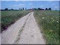
1
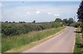
Lane at Prestberries Farm
From near the farm entrance looking north to the Malvern Hills in the distance. Can't identify the low-flying plane.
Image: © Trevor Rickard
Taken: 4 Jun 2009
0.08 miles
2
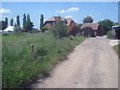
Prestberries Farm
Large farmhouse with an equally large marquee in the garden.
Image: © Trevor Rickard
Taken: 4 Jun 2009
0.09 miles
3
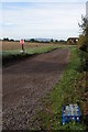
Cherry Rock Farm, Corse
The entrance to Cherry Rock Farm, the distinctive May Hill can be seen in the background.
Image: © Philip Halling
Taken: 9 Oct 2005
0.17 miles
4
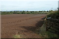
View from near Cripp's Farm
View north-west from opposite Cripp's Farm, near Blackwells End Green. On the horizon is the line of the Malvern Hills.
Image: © Philip Halling
Taken: 9 Oct 2005
0.21 miles
5
Farm track at Prestberries Farm
Looking west along the track towards the farm buildings.
Image: © Trevor Rickard
Taken: 4 Jun 2009
0.23 miles