IMAGES TAKEN NEAR TO
Church Lane, GLOUCESTER, GL19 3BX
Introduction
This page details the photographs taken nearby to Church Lane, GL19 3BX by members of the Geograph project.
The Geograph project started in 2005 with the aim of publishing, organising and preserving representative images for every square kilometre of Great Britain, Ireland and the Isle of Man.

There are currently over 7.5m images from over14,400 individuals and you can help contribute to the project by visiting https://www.geograph.org.uk
Image Map
Images are licensed for reuse under creativecommons.org/licenses/by-sa/2.0
Notes
- Clicking on the map will re-center to the selected point.
- The higher the marker number, the further away the image location is from the centre of the postcode.
Image Listing (57 Images Found)
Images are licensed for reuse under creativecommons.org/licenses/by-sa/2.0
Image
Details
Distance
1
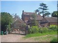
The Old Vicarage
Grade II listed former Georgian vicarage built around 1770 for the Reverend Robert Gregg - see Image
Image: © Trevor Rickard
Taken: 4 Jun 2009
0.02 miles
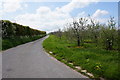
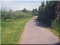
2

Single track road through cider orchards
Leading to St. Margaret's Church and Corse Court Farm.
Image: © Pauline E
Taken: 21 Aug 2008
0.03 miles
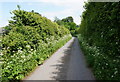
3
Church Lane
Towards St Margaret's Church, Corse.
Image: © Ian S
Taken: 26 May 2016
0.05 miles
5
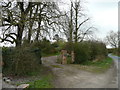
Entrance to the Old Vicarage, Corse
Which is a large brick building, surrounded by high hedges.
Image: © Jonathan Billinger
Taken: 26 Mar 2008
0.06 miles
6
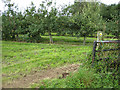
Footpath through cider orchard
Plenty of windfalls on the ground.
Image: © Pauline E
Taken: 21 Aug 2008
0.07 miles
7
Entrance to Stone End Farm
On the north side of Church Lane. Caravan site and fishery in the grounds of a Grade II listed farmhouse.
http://www.fisheries.co.uk/stoneend/index.htm
Image: © Trevor Rickard
Taken: 4 Jun 2009
0.10 miles
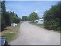
8
Stone End House and caravan site
View west from the public footpath across the two-acre caravan site to the house which is 17th century with a large 18th-century addition on the left.
http://www.fisheries.co.uk/stoneend/index.htm
Image: © Trevor Rickard
Taken: 4 Jun 2009
0.10 miles
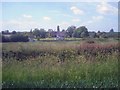
9
Church Lane
Looking north-east along the lane with extensive orchards on the left and more behind the tree-line on the right. Corse Wood Hill in the distance.
Image: © Trevor Rickard
Taken: 4 Jun 2009
0.11 miles
10
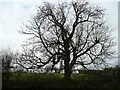
Tree by the caravan site
By Stone End House, Corse.
Image: © Jonathan Billinger
Taken: 26 Mar 2008
0.13 miles