IMAGES TAKEN NEAR TO
Corsend Road, GLOUCESTER, GL19 3BP
Introduction
This page details the photographs taken nearby to Corsend Road, GL19 3BP by members of the Geograph project.
The Geograph project started in 2005 with the aim of publishing, organising and preserving representative images for every square kilometre of Great Britain, Ireland and the Isle of Man.

There are currently over 7.5m images from over14,400 individuals and you can help contribute to the project by visiting https://www.geograph.org.uk
Image Map
Images are licensed for reuse under creativecommons.org/licenses/by-sa/2.0
Notes
- Clicking on the map will re-center to the selected point.
- The higher the marker number, the further away the image location is from the centre of the postcode.
Image Listing (28 Images Found)
Images are licensed for reuse under creativecommons.org/licenses/by-sa/2.0
Image
Details
Distance
1
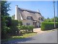
Thatched cottage on Corsend Road
One of many thatched cottages around Hartpury, many of which are listed buildings.
Image: © Trevor Rickard
Taken: 4 Jun 2009
0.01 miles
2
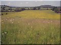
Farmland west of Hartpury
Looking west to Limbury Hill. This hay field is full of buttercups at the lower level.
Image: © Trevor Rickard
Taken: 4 Jun 2009
0.09 miles
3
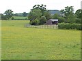
Barn near Hartpury
The barn adjoins a meadow at the southern edge of the square. Taken from footpath GHA/18/1; the meadow is crossed by no fewer than four footpaths.
Image: © Derek Harper
Taken: 28 May 2009
0.10 miles
4
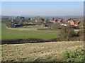
View over the western edge of Hartpury
Towards Corsend Farm.
Image: © Pauline E
Taken: 11 Feb 2008
0.13 miles
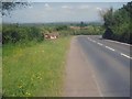
5
Postbox on Corsend Road, Hartpury
Approaching the junction with the A417, Ledbury to Gloucester road.
Image: © Pauline E
Taken: 11 Feb 2008
0.14 miles
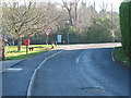
6
Junction of Corsend Road and A417
Turn off for the Church and Bee Shelter Image
Image: © Julian P Guffogg
Taken: 7 Aug 2013
0.14 miles
7
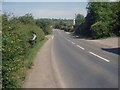
A417 at Hartpury
Looking northwards with Corsend Road off to the left.
Image: © Trevor Rickard
Taken: 4 Jun 2009
0.16 miles
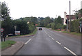
8
Bend in the A417
View northwards as the road descends to link the lower part of Hartpury village. The brown sign indicates that the "Hartpury Church and Bee Shelter" are along the next turning, which are well worth a visit. What it doesn't tell you is that it is a further two-and-a-half miles away. So the church is not quite at the village centre! Malvern Hills in the distance on the right.
Image: © Trevor Rickard
Taken: 4 Jun 2009
0.16 miles
9
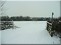
Footpath across a snowy field
Looking south-east from Corsend towards Hartpury.
Image: © Jonathan Billinger
Taken: 21 Dec 2010
0.16 miles
10
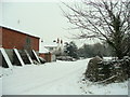
Corsend Farm
The roads are passable with care on the December afternoon.
Image: © Jonathan Billinger
Taken: 21 Dec 2010
0.16 miles