IMAGES TAKEN NEAR TO
Taynton, GLOUCESTER, GL19 3AN
Introduction
This page details the photographs taken nearby to GL19 3AN by members of the Geograph project.
The Geograph project started in 2005 with the aim of publishing, organising and preserving representative images for every square kilometre of Great Britain, Ireland and the Isle of Man.

There are currently over 7.5m images from over14,400 individuals and you can help contribute to the project by visiting https://www.geograph.org.uk
Image Map
Images are licensed for reuse under creativecommons.org/licenses/by-sa/2.0
Notes
- Clicking on the map will re-center to the selected point.
- The higher the marker number, the further away the image location is from the centre of the postcode.
Image Listing (20 Images Found)
Images are licensed for reuse under creativecommons.org/licenses/by-sa/2.0
Image
Details
Distance
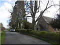
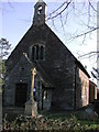
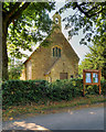
1
Taynton Church
Taynton church is dedicated to St Lawrence. The church is unusual in that it was built during the Commonwealth, between 1650 and 1660. It replaced an earlier medieval church which was situated almost a mile to the north-east; this earlier church was destroyed in the English Civil War in 1643. The other unusual feature is that the church lies on a north/south orientation.
Image: © Philip Halling
Taken: 22 Apr 2007
0.01 miles
2
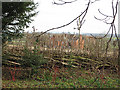
Coppiced hedge at Taynton
By the footpath.
Image: © Pauline E
Taken: 2 Feb 2008
0.02 miles
3

The Old Rectory, Taynton
Designed by John Hayward in 1849.
Image: © Jonathan Thacker
Taken: 30 Jun 2011
0.02 miles
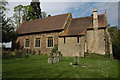
4
A seat in the churchyard, St. Lawrence's, Taynton
Quiet and well cared for.
Image: © Pauline E
Taken: 2 Feb 2008
0.02 miles
5
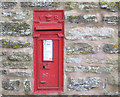
Victorian postbox, Taynton
Near to the church of St.Lawrence.
Image: © Pauline E
Taken: 2 Feb 2008
0.03 miles
7
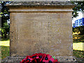
Taynton War Memorial (detail)
The dedication, on the east face of the stone pedestal, is becoming difficult to read due to weathering:
IN PROUD MEMORY OF
THE MEN OF TAYNTON
WHO GAVE THEIR LIVES
IN THE GREAT WAR
1914–1918.
See Image]
Image: © David Dixon
Taken: 29 Jul 2019
0.04 miles
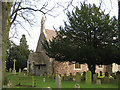
8
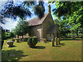
The Parish Church of St Lawrence, Taynton
St Lawrence’s Church is a Grade II* listed building (Historic England List Entry Number: 1152696 https://historicengland.org.uk/listing/the-list/list-entry/1152696 ). The present building dates from 1650.
According to UK Genealogy Archives https://ukga.org/churches/Gloucestershire/2180.html “The ancient church of St. Lawrence, distant about 1½ miles from the village, together with the minister's house and outbuildings, were burned to the ground by a force of Royalists under Capt. Wiffin, a few days after the raising of the siege of Gloucester, at the beginning of Sept, 1643”.
The new church, a single-cell building which forms the present nave, was built by order of Parliament in 1650 for Presbyterian worship. It was enlarged during the nineteenth century.
Image: © David Dixon
Taken: 29 Jul 2019
0.04 miles
9
Taynton, St Lawrence's Church
St Lawrence’s Church is a Grade II* listed building (Historic England List Entry Number: 1152696 https://historicengland.org.uk/listing/the-list/list-entry/1152696 ). The present building dates from 1650.
According to UK Genealogy Archives https://ukga.org/churches/Gloucestershire/2180.html “The ancient church of St. Lawrence, distant about 1½ miles from the village, together with the minister's house and outbuildings, was burned to the ground by a force of Royalists under Capt. Wiffin, a few days after the raising of the siege of Gloucester, at the beginning of Sept 1643”.
The new church, a single-cell building which forms the present nave, was built by order of Parliament in 1650 for Presbyterian worship. It was enlarged during the nineteenth century.
Image: © David Dixon
Taken: 29 Jul 2019
0.04 miles