IMAGES TAKEN NEAR TO
Wynford Villas, GLOUCESTER, GL19 3AL
Introduction
This page details the photographs taken nearby to Wynford Villas, GL19 3AL by members of the Geograph project.
The Geograph project started in 2005 with the aim of publishing, organising and preserving representative images for every square kilometre of Great Britain, Ireland and the Isle of Man.

There are currently over 7.5m images from over14,400 individuals and you can help contribute to the project by visiting https://www.geograph.org.uk
Image Map
Images are licensed for reuse under creativecommons.org/licenses/by-sa/2.0
Notes
- Clicking on the map will re-center to the selected point.
- The higher the marker number, the further away the image location is from the centre of the postcode.
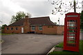
Image Listing (11 Images Found)
Images are licensed for reuse under creativecommons.org/licenses/by-sa/2.0
Image
Details
Distance
1
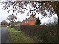
Wynford Villas
Post 1st world war council houses in this land fit for heroes. Perhaps the best war memorial we could have.
Image: © Bob Embleton
Taken: 14 Dec 2005
0.08 miles
3
Footpath heads north from Taynton
Leading to earthworks.
Image: © Pauline E
Taken: 2 Feb 2008
0.14 miles
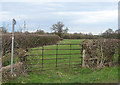
5
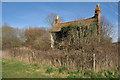
Derelict cottage, Taynton
This derelict cottage without access to the road other than by footpath is in a sorry state with the side wall gone. It is situated near the site of ancient earthworks and the site of a motte and bailey.
Image: © Philip Halling
Taken: 13 Mar 2011
0.16 miles
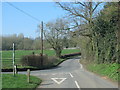
6
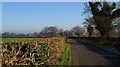
From Taynton to May Hill -1
Looking back toward Taynton.
Image: © David Robinson
Taken: 7 Dec 2008
0.17 miles
7
Earthworks at Taynton
In this land to the east of present day Taynton are earthworks, the site of a motte and bailey and a moat. I assume that the site of Taynton church which was destroyed in the Civil War was situated hereabouts?
Image: © Philip Halling
Taken: 13 Mar 2011
0.19 miles
8
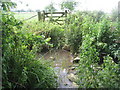
Former footpath between Tibberton and Taynton
The gate and stepping stones would seem to indicate that at one time there was a footpath here.
Image: © Jonathan Thacker
Taken: 30 Jun 2011
0.19 miles
9
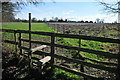
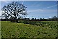
Footpath and stile
Footpath and stile to the east of the village of taynton.
Image: © Philip Halling
Taken: 13 Mar 2011
0.20 miles
10
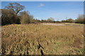
Marshy ground, Taynton
This wet marshy land is near the site of a motte and bailey to the east of Taynton.
Image: © Philip Halling
Taken: 13 Mar 2011
0.22 miles